Frasdorf geodata
Frasdorf (Bavaria) is a seat of a fourth-order administrative division; located in Germany in Europe/Berlin (GMT+2) time zone. With population of 3,005 people, there are 3993 cities with bigger population in this country. Compared to other cities in Germany, 97.7% of cities are located further ↑North; 85.7% of cities are located further ←West and 95.1% of cities have lower elevation than Frasdorf. Note1
Administrative division(s):
- Level 1: Bavaria
- Level 2: Upper Bavaria
- Level 3: Landkreis Rosenheim
- Level 4: Frasdorf


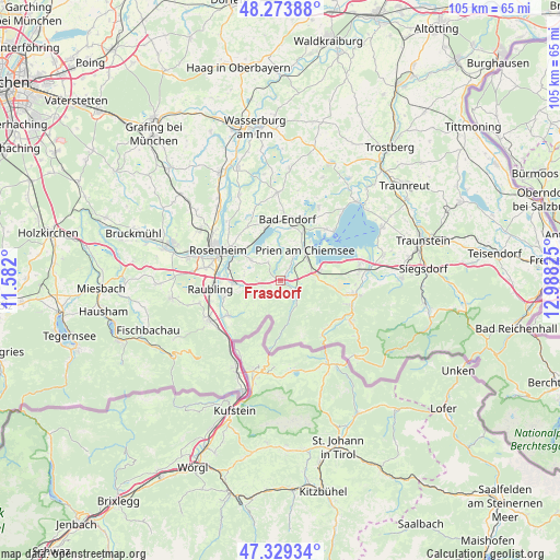
Frasdorf GPS coordinates[2]
47° 48' 13.536" North, 12° 17' 6.432" East
| Map corner | latitude | longitude |
|---|---|---|
| Upper-left | 48.27388°, | 11.582° |
| Center: | 47.80376°, | 12.28512° |
| Lower-right: | 47.32934°, | 12.98825° |
| Map W x H: | 105×105 km | = 65.2×65.2mi |
| max Lat: | 55.01917° ⇑97.7% North |
| Frasdorf: | 47.80376° |
| min Lat: | ⇓2.3% South 47.40724° |
| min Long | Frasdorf | max Long |
| 5.92978° | 12.28512° | 14.98853° |
| W 85.7%⇐ | ⇒14.3% E |
Elevation
Elevation of Frasdorf is 602 m = 1975 ft, and this is 352.9 m = 1158 ft above average elevation for this country.
| Max E: |
1256 m = 4121 ft | 4.9% |
| Frasdorf | 602 m 1975 ft | |
| Avg. | 249.1 m = 817 ft | |
Min E: |
-5 m = -16 ft | 95.1% |
See also: Germany elevation on elevation.city.
Geographical zone
Frasdorf is located in North temperate zone (between Tropic of Cancer and the Arctic Circle). Distance of this North polar circle is 2085.9 km =1296.1 mi to North.| Distance of | km | miles | from Frasdorf |
|---|---|---|---|
| North Pole | 4691.8 | 2915.3 | to North |
| Arctic Circle | 2085.9 | 1296.1 | to North |
| Tropic Cancer | 2709.4 | 1683.5 | to South |
| Equator | 5315.3 | 3302.8 | to South |


Nearby cities:
15 places around Frasdorf: (largest is in red/bold)
• Altenmarkt
11.5 km =7.1 mi,  256°
256°
• Aschau im Chiemgau
4.1 km =2.5 mi,  136°
136°
• Bad Endorf
11.7 km =7.3 mi,  4°
4°
• Bernau am Chiemsee
6.8 km =4.2 mi,  82°
82°
• Chiemsee
12.1 km =7.5 mi,  54°
54°
• Neubeuern
11.3 km =7 mi,  252°
252°
• Nußdorf am Inn
11.8 km =7.3 mi,  234°
234°
• Prien am Chiemsee
7.4 km =4.6 mi,  38°
38°
• Prutting
11.7 km =7.3 mi,  328°
328°
• Riedering
7 km =4.3 mi,  303°
303°
• Rimsting
9.4 km =5.8 mi,  24°
24°
• Rohrdorf
8.6 km =5.3 mi,  265°
265°
• Samerberg
7.6 km =4.7 mi, 246°
• Schleching
12.3 km =7.6 mi, 138°
• Stephanskirchen
9.3 km =5.8 mi,  306°
306°
Sources, notices
• [Note1] Compared only with cities in Germany existing in our database
• [Src1] Map data: © OpenStreetMap contributors (CC-BY-SA)
• [Src2] Other city data from geonames.org with taken over terms of usage.
• [Src3] Geographical zone / Annual Mean Temperature by Robert A. Rohde @ Wikipedia
