Chamerau geodata
Chamerau (Bavaria) is a seat of a fourth-order administrative division; located in Germany in Europe/Berlin (GMT+2) time zone. With population of 2,667 people, there are 4260 cities with bigger population in this country. Compared to other cities in Germany, 80.3% of cities are located further ↑North; 90.3% of cities are located further ←West and 71.8% of cities have lower elevation than Chamerau. Note1
Administrative division(s):
- Level 1: Bavaria
- Level 2: Upper Palatinate
- Level 3: Landkreis Cham
- Level 4: Chamerau


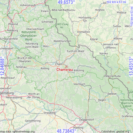
Chamerau GPS coordinates[2]
49° 12' 0" North, 12° 45' 0" East
| Map corner | latitude | longitude |
|---|---|---|
| Upper-left | 49.6573°, | 12.04688° |
| Center: | 49.2°, | 12.75° |
| Lower-right: | 48.73843°, | 13.45313° |
| Map W x H: | 102.2×102.2 km | = 63.5×63.5mi |
| max Lat: | 55.01917° ⇑80.3% North |
| Chamerau: | 49.2° |
| min Lat: | ⇓19.7% South 47.40724° |
| min Long | Chamerau | max Long |
| 5.92978° | 12.75° | 14.98853° |
| W 90.3%⇐ | ⇒9.7% E |
Elevation
Elevation of Chamerau is 373 m = 1224 ft, and this is 123.9 m = 406 ft above average elevation for this country.
| Max E: |
1256 m = 4121 ft | 28.2% |
| Chamerau | 373 m 1224 ft | |
| Avg. | 249.1 m = 817 ft | |
Min E: |
-5 m = -16 ft | 71.8% |
See also: Germany elevation on elevation.city.
Geographical zone
Chamerau is located in North temperate zone (between Tropic of Cancer and the Arctic Circle). Distance of this North polar circle is 1930.6 km =1199.6 mi to North.| Distance of | km | miles | from Chamerau |
|---|---|---|---|
| North Pole | 4536.5 | 2818.8 | to North |
| Arctic Circle | 1930.6 | 1199.6 | to North |
| Tropic Cancer | 2864.6 | 1780 | to South |
| Equator | 5470.5 | 3399.2 | to South |


Nearby cities:
15 places around Chamerau: (largest is in red/bold)
• Arnschwang
9.8 km =6.1 mi,  29°
29°
• Blaibach
6.1 km =3.8 mi,  127°
127°
• Cham
7.5 km =4.7 mi,  292°
292°
• Grafenwiesen
9.7 km =6 mi,  90°
90°
• Kötzting
8.1 km =5 mi,  108°
108°
• Miltach
4.4 km =2.7 mi,  162°
162°
• Pemfling
12.2 km =7.6 mi,  307°
307°
• Rimbach
10.4 km =6.5 mi,  69°
69°
• Runding
1.9 km =1.2 mi, 27°
• Schorndorf
12.2 km =7.6 mi,  248°
248°
• Traitsching
9.2 km =5.7 mi,  232°
232°
• Waffenbrunn
9.6 km =6 mi,  320°
320°
• Weiding
7 km =4.3 mi,  7°
7°
• Willmering
8.2 km =5.1 mi, 312°
• Zandt
5.7 km =3.5 mi,  192°
192°
Sources, notices
• [Note1] Compared only with cities in Germany existing in our database
• [Src1] Map data: © OpenStreetMap contributors (CC-BY-SA)
• [Src2] Other city data from geonames.org with taken over terms of usage.
• [Src3] Geographical zone / Annual Mean Temperature by Robert A. Rohde @ Wikipedia
