Schorndorf geodata
Schorndorf (Bavaria) is a seat of a fourth-order administrative division; located in Germany in Europe/Berlin (GMT+2) time zone. With population of 2,554 people, there are 4378 cities with bigger population in this country. Compared to other cities in Germany, 80.9% of cities are located further ↑North; 88.8% of cities are located further ←West and 77.7% of cities have lower elevation than Schorndorf. Note1
Administrative division(s):
- Level 1: Bavaria
- Level 2: Upper Palatinate
- Level 3: Landkreis Cham
- Level 4: Schorndorf


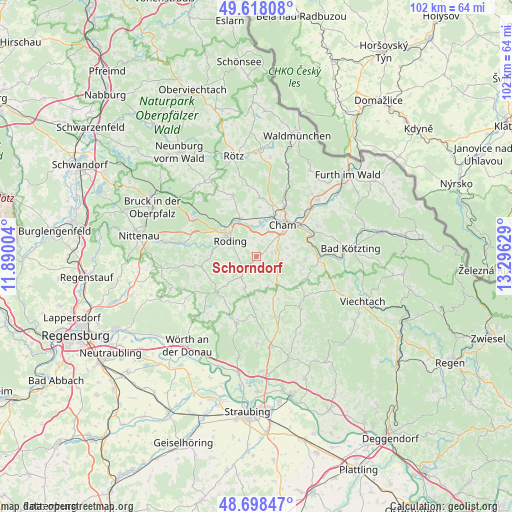
Schorndorf GPS coordinates[2]
49° 9' 37.476" North, 12° 35' 35.376" East
| Map corner | latitude | longitude |
|---|---|---|
| Upper-left | 49.61808°, | 11.89004° |
| Center: | 49.16041°, | 12.59316° |
| Lower-right: | 48.69847°, | 13.29629° |
| Map W x H: | 102.3×102.2 km | = 63.6×63.5mi |
| max Lat: | 55.01917° ⇑80.9% North |
| Schorndorf: | 49.16041° |
| min Lat: | ⇓19.1% South 47.40724° |
| min Long | Schorndorf | max Long |
| 5.92978° | 12.59316° | 14.98853° |
| W 88.8%⇐ | ⇒11.2% E |
Elevation
Elevation of Schorndorf is 417 m = 1368 ft, and this is 167.9 m = 551 ft above average elevation for this country.
| Max E: |
1256 m = 4121 ft | 22.3% |
| Schorndorf | 417 m 1368 ft | |
| Avg. | 249.1 m = 817 ft | |
Min E: |
-5 m = -16 ft | 77.7% |
See also: Germany elevation on elevation.city.
Geographical zone
Schorndorf is located in North temperate zone (between Tropic of Cancer and the Arctic Circle). Distance of this North polar circle is 1935 km =1202.4 mi to North.| Distance of | km | miles | from Schorndorf |
|---|---|---|---|
| North Pole | 4540.9 | 2821.6 | to North |
| Arctic Circle | 1935 | 1202.4 | to North |
| Tropic Cancer | 2860.2 | 1777.2 | to South |
| Equator | 5466.1 | 3396.5 | to South |


Nearby cities:
15 places around Schorndorf: (largest is in red/bold)
• Cham
8.5 km =5.3 mi,  31°
31°
• Chamerau
12.2 km =7.6 mi,  68°
68°
• Falkenstein
10.4 km =6.5 mi,  227°
227°
• Konzell
13 km =8.1 mi,  138°
138°
• Loitzendorf
9.6 km =6 mi,  151°
151°
• Michelsneukirchen
5.1 km =3.2 mi,  215°
215°
• Miltach
12.7 km =7.9 mi,  89°
89°
• Pemfling
11.9 km =7.4 mi,  8°
8°
• Pösing
8.7 km =5.4 mi,  338°
338°
• Roding
6.5 km =4 mi,  305°
305°
• Stamsried
12.8 km =8 mi, 339°
• Traitsching
4.3 km =2.7 mi,  105°
105°
• Waffenbrunn
13 km =8.1 mi,  24°
24°
• Willmering
11.3 km =7 mi, 28°
• Zandt
10.3 km =6.4 mi,  96°
96°
Sources, notices
• [Note1] Compared only with cities in Germany existing in our database
• [Src1] Map data: © OpenStreetMap contributors (CC-BY-SA)
• [Src2] Other city data from geonames.org with taken over terms of usage.
• [Src3] Geographical zone / Annual Mean Temperature by Robert A. Rohde @ Wikipedia
