Rimbach geodata
Rimbach (Bavaria) is a seat of a fourth-order administrative division; located in Germany in Europe/Berlin (GMT+2) time zone. With population of 2,022 people, there are 5040 cities with bigger population in this country. Compared to other cities in Germany, 79.9% of cities are located further ↑North; 91.4% of cities are located further ←West and 94.5% of cities have lower elevation than Rimbach. Note1
Administrative division(s):
- Level 1: Bavaria
- Level 2: Upper Palatinate
- Level 3: Landkreis Cham
- Level 4: Rimbach


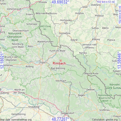
Rimbach GPS coordinates[2]
49° 13' 59.988" North, 12° 52' 59.988" East
| Map corner | latitude | longitude |
|---|---|---|
| Upper-left | 49.69032°, | 12.18021° |
| Center: | 49.23333°, | 12.88333° |
| Lower-right: | 48.77207°, | 13.58646° |
| Map W x H: | 102.1×102.1 km | = 63.4×63.4mi |
| max Lat: | 55.01917° ⇑79.9% North |
| Rimbach: | 49.23333° |
| min Lat: | ⇓20.1% South 47.40724° |
| min Long | Rimbach | max Long |
| 5.92978° | 12.88333° | 14.98853° |
| W 91.4%⇐ | ⇒8.6% E |
Elevation
Elevation of Rimbach is 587 m = 1926 ft, and this is 337.9 m = 1109 ft above average elevation for this country.
| Max E: |
1256 m = 4121 ft | 5.5% |
| Rimbach | 587 m 1926 ft | |
| Avg. | 249.1 m = 817 ft | |
Min E: |
-5 m = -16 ft | 94.5% |
See also: Germany elevation on elevation.city.
Geographical zone
Rimbach is located in North temperate zone (between Tropic of Cancer and the Arctic Circle). Distance of this North polar circle is 1926.9 km =1197.3 mi to North.| Distance of | km | miles | from Rimbach |
|---|---|---|---|
| North Pole | 4532.8 | 2816.6 | to North |
| Arctic Circle | 1926.9 | 1197.3 | to North |
| Tropic Cancer | 2868.3 | 1782.3 | to South |
| Equator | 5474.2 | 3401.5 | to South |


Nearby cities:
15 places around Rimbach: (largest is in red/bold)
• Arnbruck
14.2 km =8.8 mi,  143°
143°
• Arnschwang
6.9 km =4.3 mi,  314°
314°
• Arrach
9.3 km =5.8 mi,  120°
120°
• Blaibach
8.9 km =5.5 mi,  213°
213°
• Chamerau
10.4 km =6.5 mi,  249°
249°
• Eschlkam
7.7 km =4.8 mi,  17°
17°
• Furth im Wald
9 km =5.6 mi,  340°
340°
• Grafenwiesen
3.7 km =2.3 mi,  180°
180°
• Hohenwarth
5.2 km =3.2 mi, 135°
• Kötzting
6.6 km =4.1 mi,  197°
197°
• Lam
12.8 km =8 mi,  108°
108°
• Miltach
11.5 km =7.1 mi,  226°
226°
• Neukirchen
6.9 km =4.3 mi,  64°
64°
• Runding
9 km =5.6 mi,  257°
257°
• Weiding
9.3 km =5.8 mi,  290°
290°
Sources, notices
• [Note1] Compared only with cities in Germany existing in our database
• [Src1] Map data: © OpenStreetMap contributors (CC-BY-SA)
• [Src2] Other city data from geonames.org with taken over terms of usage.
• [Src3] Geographical zone / Annual Mean Temperature by Robert A. Rohde @ Wikipedia
