Cattenstedt geodata
Cattenstedt (Saxony-Anhalt) is a populated place; located in Germany in Europe/Berlin (GMT+2) time zone. With population of 727 people, there are 8206 cities with bigger population in this country. Compared to other cities in Germany, 69.7% of cities are located further ↓South; 66.5% of cities are located further ←West and 54.1% of cities have lower elevation than Cattenstedt. Note1
Administrative division(s):
- Level 1: Saxony-Anhalt
- Level 3: Landkreis Harz
- Level 4: Blankenburg (Harz)


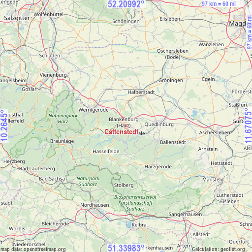
Cattenstedt GPS coordinates[2]
51° 46' 37.092" North, 10° 58' 3.432" East
| Map corner | latitude | longitude |
|---|---|---|
| Upper-left | 52.20992°, | 10.2645° |
| Center: | 51.77697°, | 10.96762° |
| Lower-right: | 51.33983°, | 11.67075° |
| Map W x H: | 96.7×96.7 km | = 60.1×60.1mi |
| max Lat: | 55.01917° ⇑30.3% North |
| Cattenstedt: | 51.77697° |
| min Lat: | ⇓69.7% South 47.40724° |
| min Long | Cattenstedt | max Long |
| 5.92978° | 10.96762° | 14.98853° |
| W 66.5%⇐ | ⇒33.5% E |
Elevation
Elevation of Cattenstedt is 252 m = 827 ft, and this is 2.9 m = 10 ft above average elevation for this country.
| Max E: |
1256 m = 4121 ft | 45.9% |
| Cattenstedt | 252 m 827 ft | |
| Avg. | 249.1 m = 817 ft | |
Min E: |
-5 m = -16 ft | 54.1% |
See also: Germany elevation on elevation.city.
Geographical zone
Cattenstedt is located in North temperate zone (between Tropic of Cancer and the Arctic Circle). Distance of this North polar circle is 1644.1 km =1021.6 mi to North.| Distance of | km | miles | from Cattenstedt |
|---|---|---|---|
| North Pole | 4250 | 2640.8 | to North |
| Arctic Circle | 1644.1 | 1021.6 | to North |
| Tropic Cancer | 3151.1 | 1958 | to South |
| Equator | 5757.1 | 3577.3 | to South |


Nearby cities:
15 places around Cattenstedt: (largest is in red/bold)
• Allrode
10.9 km =6.8 mi,  179°
179°
• Blankenburg
1.7 km =1.1 mi,  329°
329°
• Elbingerode
11.2 km =7 mi,  266°
266°
• Friedrichsbrunn
10.8 km =6.7 mi,  153°
153°
• Heimburg
6.4 km =4 mi,  323°
323°
• Hüttenrode
4.5 km =2.8 mi,  258°
258°
• Langenstein
8.8 km =5.5 mi,  9°
9°
• Neinstedt
8.8 km =5.5 mi,  110°
110°
• Rübeland
8.7 km =5.4 mi,  254°
254°
• Stecklenberg
9.6 km =6 mi,  120°
120°
• Thale
6 km =3.7 mi, 121°
• Timmenrode
2.7 km =1.7 mi,  103°
103°
• Weddersleben
8.2 km =5.1 mi, 99°
• Westerhausen
6.9 km =4.3 mi,  62°
62°
• Wienrode
1.4 km =0.9 mi,  165°
165°
Sources, notices
• [Note1] Compared only with cities in Germany existing in our database
• [Src1] Map data: © OpenStreetMap contributors (CC-BY-SA)
• [Src2] Other city data from geonames.org with taken over terms of usage.
• [Src3] Geographical zone / Annual Mean Temperature by Robert A. Rohde @ Wikipedia
