Hüttenrode geodata
Hüttenrode (Saxony-Anhalt) is a populated place; located in Germany in Europe/Berlin (GMT+2) time zone. With population of 1,204 people, there are 6550 cities with bigger population in this country. Compared to other cities in Germany, 69.6% of cities are located further ↓South; 65.5% of cities are located further ←West and 86.2% of cities have lower elevation than Hüttenrode. Note1
Administrative division(s):
- Level 1: Saxony-Anhalt
- Level 3: Landkreis Harz
- Level 4: Blankenburg (Harz)


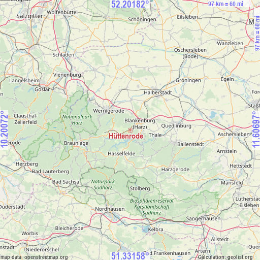
Hüttenrode GPS coordinates[2]
51° 46' 7.68" North, 10° 54' 13.824" East
| Map corner | latitude | longitude |
|---|---|---|
| Upper-left | 52.20182°, | 10.20072° |
| Center: | 51.7688°, | 10.90384° |
| Lower-right: | 51.33158°, | 11.60697° |
| Map W x H: | 96.8×96.8 km | = 60.1×60.1mi |
| max Lat: | 55.01917° ⇑30.4% North |
| Hüttenrode: | 51.7688° |
| min Lat: | ⇓69.6% South 47.40724° |
| min Long | Hüttenrode | max Long |
| 5.92978° | 10.90384° | 14.98853° |
| W 65.5%⇐ | ⇒34.5% E |
Elevation
Elevation of Hüttenrode is 479 m = 1572 ft, and this is 229.9 m = 754 ft above average elevation for this country.
| Max E: |
1256 m = 4121 ft | 13.8% |
| Hüttenrode | 479 m 1572 ft | |
| Avg. | 249.1 m = 817 ft | |
Min E: |
-5 m = -16 ft | 86.2% |
See also: Germany elevation on elevation.city.
Geographical zone
Hüttenrode is located in North temperate zone (between Tropic of Cancer and the Arctic Circle). Distance of this North polar circle is 1645 km =1022.2 mi to North.| Distance of | km | miles | from Hüttenrode |
|---|---|---|---|
| North Pole | 4250.9 | 2641.4 | to North |
| Arctic Circle | 1645 | 1022.2 | to North |
| Tropic Cancer | 3150.2 | 1957.4 | to South |
| Equator | 5756.2 | 3576.7 | to South |


Nearby cities:
15 places around Hüttenrode: (largest is in red/bold)
• Allrode
10.9 km =6.8 mi,  155°
155°
• Blankenburg
4.3 km =2.7 mi,  55°
55°
• Cattenstedt
4.5 km =2.8 mi,  78°
78°
• Derenburg
11.4 km =7.1 mi,  2°
2°
• Elbingerode
6.8 km =4.2 mi,  271°
271°
• Hasselfelde
9.4 km =5.8 mi,  201°
201°
• Heimburg
6.1 km =3.8 mi, 4°
• Königshütte
10 km =6.2 mi,  253°
253°
• Langenstein
11.3 km =7 mi,  31°
31°
• Rübeland
4.2 km =2.6 mi, 250°
• Thale
9.7 km =6 mi,  103°
103°
• Timmenrode
7.1 km =4.4 mi,  87°
87°
• Wernigerode
11.3 km =7 mi,  311°
311°
• Westerhausen
11.3 km =7 mi,  68°
68°
• Wienrode
4.8 km =3 mi, 94°
Sources, notices
• [Note1] Compared only with cities in Germany existing in our database
• [Src1] Map data: © OpenStreetMap contributors (CC-BY-SA)
• [Src2] Other city data from geonames.org with taken over terms of usage.
• [Src3] Geographical zone / Annual Mean Temperature by Robert A. Rohde @ Wikipedia
