Langenstein geodata
Langenstein (Saxony-Anhalt) is a populated place; located in Germany in Europe/Berlin (GMT+2) time zone. With population of 1,996 people, there are 5078 cities with bigger population in this country. Compared to other cities in Germany, 70.6% of cities are located further ↓South; 66.8% of cities are located further ←West and 60.4% of cities have higher elevation than Langenstein. Note1


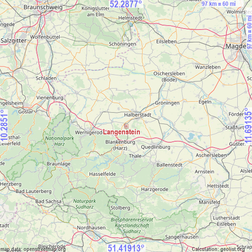
Langenstein GPS coordinates[2]
51° 51' 19.836" North, 10° 59' 17.592" East
| Map corner | latitude | longitude |
|---|---|---|
| Upper-left | 52.2877°, | 10.2851° |
| Center: | 51.85551°, | 10.98822° |
| Lower-right: | 51.41913°, | 11.69135° |
| Map W x H: | 96.6×96.6 km | = 60×60mi |
| max Lat: | 55.01917° ⇑29.4% North |
| Langenstein: | 51.85551° |
| min Lat: | ⇓70.6% South 47.40724° |
| min Long | Langenstein | max Long |
| 5.92978° | 10.98822° | 14.98853° |
| W 66.8%⇐ | ⇒33.2% E |
Elevation
Elevation of Langenstein is 149 m = 489 ft, and this is 100.1 m = 328 ft below average elevation for this country.
| Max E: |
1256 m = 4121 ft | 60.4% |
| Avg. | 249.1 m = 817 ft | |
| Langenstein | 149 m = 489 ft | |
Min E: |
-5 m = -16 ft | 39.6% |
See also: Germany elevation on elevation.city.
Geographical zone
Langenstein is located in North temperate zone (between Tropic of Cancer and the Arctic Circle). Distance of this North polar circle is 1635.4 km =1016.2 mi to North.| Distance of | km | miles | from Langenstein |
|---|---|---|---|
| North Pole | 4241.3 | 2635.4 | to North |
| Arctic Circle | 1635.4 | 1016.2 | to North |
| Tropic Cancer | 3159.9 | 1963.5 | to South |
| Equator | 5765.8 | 3582.7 | to South |


Nearby cities:
15 places around Langenstein: (largest is in red/bold)
• Aspenstedt
9.3 km =5.8 mi,  343°
343°
• Blankenburg
7.6 km =4.7 mi,  197°
197°
• Cattenstedt
8.8 km =5.5 mi,  189°
189°
• Danstedt
9.4 km =5.8 mi,  311°
311°
• Derenburg
5.6 km =3.5 mi,  287°
287°
• Halberstadt
6.5 km =4 mi,  46°
46°
• Harsleben
7.8 km =4.8 mi,  80°
80°
• Heimburg
6.4 km =4 mi,  235°
235°
• Heudeber
11.2 km =7 mi,  297°
297°
• Hüttenrode
11.3 km =7 mi,  211°
211°
• Sargstedt
9.5 km =5.9 mi,  359°
359°
• Ströbeck
7.2 km =4.5 mi, 335°
• Timmenrode
9.5 km =5.9 mi,  172°
172°
• Westerhausen
7.3 km =4.5 mi,  139°
139°
• Wienrode
10.1 km =6.3 mi, 186°
Sources, notices
• [Note1] Compared only with cities in Germany existing in our database
• [Src1] Map data: © OpenStreetMap contributors (CC-BY-SA)
• [Src2] Other city data from geonames.org with taken over terms of usage.
• [Src3] Geographical zone / Annual Mean Temperature by Robert A. Rohde @ Wikipedia
