Elbingerode geodata
Elbingerode (Saxony-Anhalt) is a populated place; located in Germany in Europe/Berlin (GMT+2) time zone. With population of 4,112 people, there are 3219 cities with bigger population in this country. Compared to other cities in Germany, 69.6% of cities are located further ↓South; 64.1% of cities are located further ←West and 84.3% of cities have lower elevation than Elbingerode. Note1
Administrative division(s):
- Level 1: Saxony-Anhalt
- Level 3: Landkreis Harz
- Level 4: Oberharz am Brocken


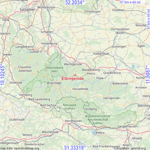
Elbingerode GPS coordinates[2]
51° 46' 13.404" North, 10° 48' 20.052" East
| Map corner | latitude | longitude |
|---|---|---|
| Upper-left | 52.2034°, | 10.10245° |
| Center: | 51.77039°, | 10.80557° |
| Lower-right: | 51.33319°, | 11.5087° |
| Map W x H: | 96.8×96.8 km | = 60.1×60.1mi |
| max Lat: | 55.01917° ⇑30.4% North |
| Elbingerode: | 51.77039° |
| min Lat: | ⇓69.6% South 47.40724° |
| min Long | Elbingerode | max Long |
| 5.92978° | 10.80557° | 14.98853° |
| W 64.1%⇐ | ⇒35.9% E |
Elevation
Elevation of Elbingerode is 463 m = 1519 ft, and this is 213.9 m = 702 ft above average elevation for this country.
| Max E: |
1256 m = 4121 ft | 15.7% |
| Elbingerode | 463 m 1519 ft | |
| Avg. | 249.1 m = 817 ft | |
Min E: |
-5 m = -16 ft | 84.3% |
See also: Germany elevation on elevation.city.
Geographical zone
Elbingerode is located in North temperate zone (between Tropic of Cancer and the Arctic Circle). Distance of this North polar circle is 1644.8 km =1022 mi to North.| Distance of | km | miles | from Elbingerode |
|---|---|---|---|
| North Pole | 4250.7 | 2641.3 | to North |
| Arctic Circle | 1644.8 | 1022 | to North |
| Tropic Cancer | 3150.4 | 1957.6 | to South |
| Equator | 5756.3 | 3576.8 | to South |


Nearby cities:
15 places around Elbingerode: (largest is in red/bold)
• Blankenburg
10.5 km =6.5 mi,  77°
77°
• Cattenstedt
11.2 km =7 mi,  86°
86°
• Darlingerode
10 km =6.2 mi,  328°
328°
• Drübeck
11.5 km =7.1 mi, 328°
• Elend
8.6 km =5.3 mi,  250°
250°
• Hasselfelde
9.5 km =5.9 mi,  159°
159°
• Heimburg
9.4 km =5.8 mi,  51°
51°
• Hüttenrode
6.8 km =4.2 mi, 91°
• Königshütte
4.1 km =2.5 mi,  222°
222°
• Reddeber
10.7 km =6.6 mi,  359°
359°
• Rübeland
3.3 km =2.1 mi,  119°
119°
• Schierke
9.9 km =6.2 mi,  265°
265°
• Tanne
9.8 km =6.1 mi, 215°
• Wernigerode
7.5 km =4.7 mi,  347°
347°
• Wienrode
11.5 km =7.1 mi, 92°
Sources, notices
• [Note1] Compared only with cities in Germany existing in our database
• [Src1] Map data: © OpenStreetMap contributors (CC-BY-SA)
• [Src2] Other city data from geonames.org with taken over terms of usage.
• [Src3] Geographical zone / Annual Mean Temperature by Robert A. Rohde @ Wikipedia
