Großlangheim geodata
Großlangheim (Bavaria) is a populated place; located in Germany in Europe/Berlin (GMT+2) time zone. With population of 1,536 people, there are 5804 cities with bigger population in this country. Compared to other cities in Germany, 70% of cities are located further ↑North; 54.2% of cities are located further ←West and 50.1% of cities have lower elevation than Großlangheim. Note1
Administrative division(s):
- Level 1: Bavaria
- Level 2: Regierungsbezirk Unterfranken
- Level 3: Landkreis Kitzingen
- Level 4: Großlangheim, Markt


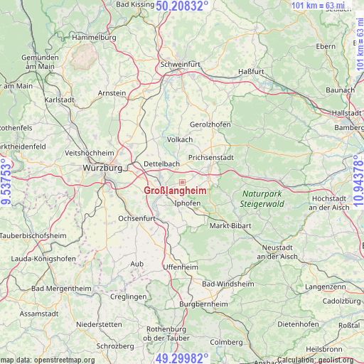
Großlangheim GPS coordinates[2]
49° 45' 22.32" North, 10° 14' 26.34" East
| Map corner | latitude | longitude |
|---|---|---|
| Upper-left | 50.20832°, | 9.53753° |
| Center: | 49.7562°, | 10.24065° |
| Lower-right: | 49.29982°, | 10.94378° |
| Map W x H: | 101×101 km | = 62.8×62.8mi |
| max Lat: | 55.01917° ⇑70% North |
| Großlangheim: | 49.7562° |
| min Lat: | ⇓30% South 47.40724° |
| min Long | Großlangheim | max Long |
| 5.92978° | 10.24065° | 14.98853° |
| W 54.2%⇐ | ⇒45.8% E |
Elevation
Elevation of Großlangheim is 226 m = 741 ft, and this is 23.1 m = 76 ft below average elevation for this country.
| Max E: |
1256 m = 4121 ft | 49.9% |
| Avg. | 249.1 m = 817 ft | |
| Großlangheim | 226 m = 741 ft | |
Min E: |
-5 m = -16 ft | 50.1% |
See also: Germany elevation on elevation.city.
Geographical zone
Großlangheim is located in North temperate zone (between Tropic of Cancer and the Arctic Circle). Distance of this North polar circle is 1868.8 km =1161.2 mi to North.| Distance of | km | miles | from Großlangheim |
|---|---|---|---|
| North Pole | 4474.7 | 2780.4 | to North |
| Arctic Circle | 1868.8 | 1161.2 | to North |
| Tropic Cancer | 2926.5 | 1818.4 | to South |
| Equator | 5532.4 | 3437.7 | to South |


Nearby cities:
15 places around Großlangheim: (largest is in red/bold)
• Albertshofen
5.4 km =3.4 mi,  282°
282°
• Buchbrunn
7.5 km =4.7 mi,  273°
273°
• Castell
8 km =5 mi,  101°
101°
• Dettelbach
7.5 km =4.7 mi,  313°
313°
• Iphofen
6.1 km =3.8 mi,  166°
166°
• Kitzingen
6.7 km =4.2 mi,  254°
254°
• Kleinlangheim
3.5 km =2.2 mi,  62°
62°
• Mainbernheim
5.6 km =3.5 mi,  196°
196°
• Mainstockheim
6.9 km =4.3 mi, 284°
• Rödelsee
3.1 km =1.9 mi,  176°
176°
• Rüdenhausen
7.2 km =4.5 mi,  82°
82°
• Sommerach
8.5 km =5.3 mi,  343°
343°
• Wiesenbronn
4.3 km =2.7 mi, 99°
• Wiesentheid
8.6 km =5.3 mi, 60°
• Willanzheim
8.5 km =5.3 mi, 183°
Sources, notices
• [Note1] Compared only with cities in Germany existing in our database
• [Src1] Map data: © OpenStreetMap contributors (CC-BY-SA)
• [Src2] Other city data from geonames.org with taken over terms of usage.
• [Src3] Geographical zone / Annual Mean Temperature by Robert A. Rohde @ Wikipedia
