Liebenau geodata
Liebenau (Hesse) is a populated place; located in Germany in Europe/Berlin (GMT+2) time zone. With population of 3,606 people, there are 3535 cities with bigger population in this country. Compared to other cities in Germany, 66.2% of cities are located further ↓South; 61% of cities are located further →East and 60.7% of cities have higher elevation than Liebenau. Note1
Administrative division(s):
- Level 1: Hesse
- Level 2: Regierungsbezirk Kassel
- Level 3: Landkreis Kassel
- Level 4: Liebenau


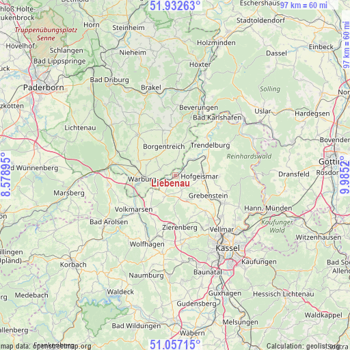
Liebenau GPS coordinates[2]
51° 29' 49.164" North, 9° 16' 55.452" East
| Map corner | latitude | longitude |
|---|---|---|
| Upper-left | 51.93263°, | 8.57895° |
| Center: | 51.49699°, | 9.28207° |
| Lower-right: | 51.05715°, | 9.9852° |
| Map W x H: | 97.3×97.3 km | = 60.5×60.5mi |
| max Lat: | 55.01917° ⇑33.8% North |
| Liebenau: | 51.49699° |
| min Lat: | ⇓66.2% South 47.40724° |
| min Long | Liebenau | max Long |
| 5.92978° | 9.28207° | 14.98853° |
| W 39%⇐ | ⇒61% E |
Elevation
Elevation of Liebenau is 147 m = 482 ft, and this is 102.1 m = 335 ft below average elevation for this country.
| Max E: |
1256 m = 4121 ft | 60.7% |
| Avg. | 249.1 m = 817 ft | |
| Liebenau | 147 m = 482 ft | |
Min E: |
-5 m = -16 ft | 39.3% |
See also: Germany elevation on elevation.city.
Geographical zone
Liebenau is located in North temperate zone (between Tropic of Cancer and the Arctic Circle). Distance of this North polar circle is 1675.2 km =1040.9 mi to North.| Distance of | km | miles | from Liebenau |
|---|---|---|---|
| North Pole | 4281.1 | 2660.2 | to North |
| Arctic Circle | 1675.2 | 1040.9 | to North |
| Tropic Cancer | 3120 | 1938.7 | to South |
| Equator | 5725.9 | 3557.9 | to South |


Nearby cities:
15 places around Liebenau: (largest is in red/bold)
• Bad Karlshafen
20.1 km =12.5 mi,  36°
36°
• Beverungen
20.1 km =12.5 mi,  18°
18°
• Borgentreich
8.5 km =5.3 mi,  340°
340°
• Breuna
11.3 km =7 mi,  216°
216°
• Calden
12.8 km =8 mi,  139°
139°
• Espenau
17.2 km =10.7 mi,  130°
130°
• Grebenstein
10.6 km =6.6 mi,  121°
121°
• Hofgeismar
7.1 km =4.4 mi,  90°
90°
• Immenhausen
15.7 km =9.8 mi, 119°
• Rhoden
18.9 km =11.7 mi,  261°
261°
• Trendelburg
12.9 km =8 mi,  48°
48°
• Udenhausen
13.1 km =8.1 mi,  106°
106°
• Volkmarsen
15 km =9.3 mi,  229°
229°
• Warburg
9.4 km =5.8 mi,  265°
265°
• Zierenberg
14.2 km =8.8 mi,  174°
174°
Sources, notices
• [Note1] Compared only with cities in Germany existing in our database
• [Src1] Map data: © OpenStreetMap contributors (CC-BY-SA)
• [Src2] Other city data from geonames.org with taken over terms of usage.
• [Src3] Geographical zone / Annual Mean Temperature by Robert A. Rohde @ Wikipedia
