Igersheim geodata
Igersheim (Baden-Württemberg) is a seat of a fourth-order administrative division; located in Germany in Europe/Berlin (GMT+2) time zone. With population of 5,700 people, there are 2565 cities with bigger population in this country. Compared to other cities in Germany, 75.8% of cities are located further ↑North; 52.5% of cities are located further →East and 50.7% of cities have higher elevation than Igersheim. Note1
Administrative division(s):
- Level 1: Baden-Württemberg
- Level 2: Regierungsbezirk Stuttgart
- Level 3: Main-Tauber-Kreis
- Level 4: Igersheim


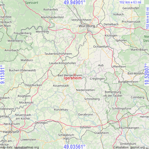
Igersheim GPS coordinates[2]
49° 29' 39.984" North, 9° 49' 0.984" East
| Map corner | latitude | longitude |
|---|---|---|
| Upper-left | 49.94901°, | 9.11381° |
| Center: | 49.49444°, | 9.81694° |
| Lower-right: | 49.03561°, | 10.52007° |
| Map W x H: | 101.6×101.6 km | = 63.1×63.1mi |
| max Lat: | 55.01917° ⇑75.8% North |
| Igersheim: | 49.49444° |
| min Lat: | ⇓24.2% South 47.40724° |
| min Long | Igersheim | max Long |
| 5.92978° | 9.81694° | 14.98853° |
| W 47.5%⇐ | ⇒52.5% E |
Elevation
Elevation of Igersheim is 220 m = 722 ft, and this is 29.1 m = 95 ft below average elevation for this country.
| Max E: |
1256 m = 4121 ft | 50.7% |
| Avg. | 249.1 m = 817 ft | |
| Igersheim | 220 m = 722 ft | |
Min E: |
-5 m = -16 ft | 49.3% |
See also: Germany elevation on elevation.city.
Geographical zone
Igersheim is located in North temperate zone (between Tropic of Cancer and the Arctic Circle). Distance of this North polar circle is 1897.9 km =1179.3 mi to North.| Distance of | km | miles | from Igersheim |
|---|---|---|---|
| North Pole | 4503.8 | 2798.5 | to North |
| Arctic Circle | 1897.9 | 1179.3 | to North |
| Tropic Cancer | 2897.3 | 1800.3 | to South |
| Equator | 5503.3 | 3419.6 | to South |


Nearby cities:
15 places around Igersheim: (largest is in red/bold)
• Assamstadt
12 km =7.5 mi,  232°
232°
• Bad Mergentheim
3.1 km =1.9 mi,  266°
266°
• Bieberehren
14.1 km =8.8 mi,  79°
79°
• Boxberg
12.9 km =8 mi,  262°
262°
• Bütthard
12.5 km =7.8 mi,  21°
21°
• Creglingen
15.7 km =9.8 mi,  100°
100°
• Dörzbach
14.7 km =9.1 mi,  212°
212°
• Gelchsheim
17 km =10.6 mi,  59°
59°
• Grünsfeld
13.7 km =8.5 mi,  338°
338°
• Lauda-Königshofen
11.1 km =6.9 mi,  315°
315°
• Niederstetten
12.9 km =8 mi,  144°
144°
• Riedenheim
13.6 km =8.5 mi, 59°
• Röttingen
11.2 km =7 mi, 81°
• Tauberrettersheim
8.6 km =5.3 mi,  90°
90°
• Weikersheim
6.2 km =3.9 mi,  106°
106°
Sources, notices
• [Note1] Compared only with cities in Germany existing in our database
• [Src1] Map data: © OpenStreetMap contributors (CC-BY-SA)
• [Src2] Other city data from geonames.org with taken over terms of usage.
• [Src3] Geographical zone / Annual Mean Temperature by Robert A. Rohde @ Wikipedia
