Egelsbach geodata
Egelsbach (Hesse) is a seat of a fourth-order administrative division; located in Germany in Europe/Berlin (GMT+2) time zone. With population of 9,645 people, there are 1676 cities with bigger population in this country. Compared to other cities in Germany, 64.6% of cities are located further ↑North; 69.5% of cities are located further →East and 64.5% of cities have higher elevation than Egelsbach. Note1
Administrative division(s):
- Level 1: Hesse
- Level 2: Regierungsbezirk Darmstadt
- Level 3: Landkreis Offenbach
- Level 4: Egelsbach


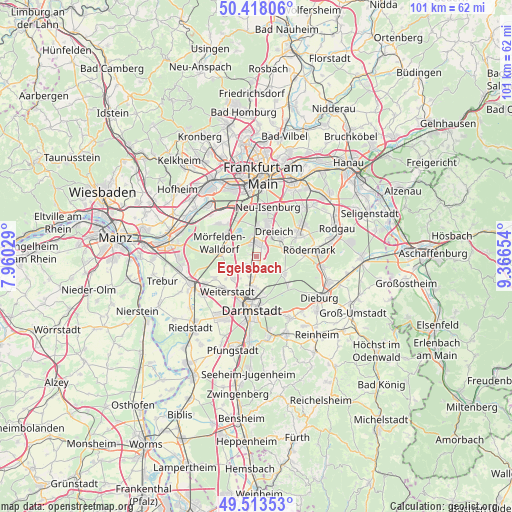
Egelsbach GPS coordinates[2]
49° 58' 4.512" North, 8° 39' 48.276" East
| Map corner | latitude | longitude |
|---|---|---|
| Upper-left | 50.41806°, | 7.96029° |
| Center: | 49.96792°, | 8.66341° |
| Lower-right: | 49.51353°, | 9.36654° |
| Map W x H: | 100.6×100.6 km | = 62.5×62.5mi |
| max Lat: | 55.01917° ⇑64.6% North |
| Egelsbach: | 49.96792° |
| min Lat: | ⇓35.4% South 47.40724° |
| min Long | Egelsbach | max Long |
| 5.92978° | 8.66341° | 14.98853° |
| W 30.5%⇐ | ⇒69.5% E |
Elevation
Elevation of Egelsbach is 124 m = 407 ft, and this is 125.1 m = 410 ft below average elevation for this country.
| Max E: |
1256 m = 4121 ft | 64.5% |
| Avg. | 249.1 m = 817 ft | |
| Egelsbach | 124 m = 407 ft | |
Min E: |
-5 m = -16 ft | 35.5% |
See also: Germany elevation on elevation.city.
Geographical zone
Egelsbach is located in North temperate zone (between Tropic of Cancer and the Arctic Circle). Distance of this North polar circle is 1845.3 km =1146.6 mi to North.| Distance of | km | miles | from Egelsbach |
|---|---|---|---|
| North Pole | 4451.2 | 2765.8 | to North |
| Arctic Circle | 1845.3 | 1146.6 | to North |
| Tropic Cancer | 2950 | 1833 | to South |
| Equator | 5555.9 | 3452.3 | to South |


Nearby cities:
15 places around Egelsbach: (largest is in red/bold)
• Büttelborn
12.3 km =7.6 mi,  234°
234°
• Darmstadt
10.7 km =6.6 mi,  185°
185°
• Dietzenbach
9.4 km =5.8 mi,  60°
60°
• Dreieich
6.2 km =3.9 mi,  21°
21°
• Eppertshausen
13.8 km =8.6 mi,  98°
98°
• Erzhausen
1.8 km =1.1 mi,  218°
218°
• Griesheim
13.6 km =8.5 mi,  208°
208°
• Heusenstamm
13.8 km =8.6 mi,  45°
45°
• Langen
2.4 km =1.5 mi,  8°
8°
• Messel
6.4 km =4 mi,  120°
120°
• Mörfelden-Walldorf
6.4 km =4 mi,  297°
297°
• Neu Isenburg
9.2 km =5.7 mi, 13°
• Niederrad
13 km =8.1 mi,  348°
348°
• Roßdorf
13.9 km =8.6 mi,  149°
149°
• Weiterstadt
8.9 km =5.5 mi, 216°
Sources, notices
• [Note1] Compared only with cities in Germany existing in our database
• [Src1] Map data: © OpenStreetMap contributors (CC-BY-SA)
• [Src2] Other city data from geonames.org with taken over terms of usage.
• [Src3] Geographical zone / Annual Mean Temperature by Robert A. Rohde @ Wikipedia
