Burgen geodata
Burgen (Rheinland-Pfalz) is a seat of a fourth-order administrative division; located in Germany in Europe/Berlin (GMT+2) time zone. With population of 580 people, there are 8920 cities with bigger population in this country. Compared to other cities in Germany, 67% of cities are located further ↑North; 93.4% of cities are located further →East and 56.8% of cities have higher elevation than Burgen. Note1
Administrative division(s):
- Level 1: Rheinland-Pfalz
- Level 3: Landkreis Bernkastel-Wittlich
- Level 4: Burgen


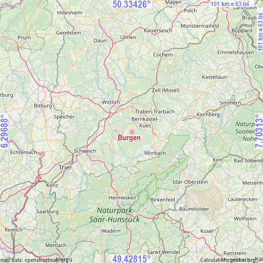
Burgen GPS coordinates[2]
49° 52' 59.988" North, 7° 0' 0" East
| Map corner | latitude | longitude |
|---|---|---|
| Upper-left | 50.33426°, | 6.29688° |
| Center: | 49.88333°, | 7° |
| Lower-right: | 49.42815°, | 7.70313° |
| Map W x H: | 100.7×100.7 km | = 62.6×62.6mi |
| max Lat: | 55.01917° ⇑67% North |
| Burgen: | 49.88333° |
| min Lat: | ⇓33% South 47.40724° |
| min Long | Burgen | max Long |
| 5.92978° | 7° | 14.98853° |
| W 6.6%⇐ | ⇒93.4% E |
Elevation
Elevation of Burgen is 176 m = 577 ft, and this is 73.1 m = 240 ft below average elevation for this country.
| Max E: |
1256 m = 4121 ft | 56.8% |
| Avg. | 249.1 m = 817 ft | |
| Burgen | 176 m = 577 ft | |
Min E: |
-5 m = -16 ft | 43.2% |
See also: Germany elevation on elevation.city.
Geographical zone
Burgen is located in North temperate zone (between Tropic of Cancer and the Arctic Circle). Distance of this North polar circle is 1854.7 km =1152.5 mi to North.| Distance of | km | miles | from Burgen |
|---|---|---|---|
| North Pole | 4460.6 | 2771.7 | to North |
| Arctic Circle | 1854.7 | 1152.5 | to North |
| Tropic Cancer | 2940.6 | 1827.2 | to South |
| Equator | 5546.5 | 3446.4 | to South |


Nearby cities:
15 places around Burgen: (largest is in red/bold)
• Bernkastel-Kues
6.6 km =4.1 mi,  56°
56°
• Brauneberg
2.8 km =1.7 mi,  331°
331°
• Gornhausen
4 km =2.5 mi,  117°
117°
• Graach
7.3 km =4.5 mi,  38°
38°
• Kesten
4 km =2.5 mi,  297°
297°
• Lieser
3.9 km =2.4 mi,  17°
17°
• Maring-Noviand
5.6 km =3.5 mi,  0°
0°
• Minheim
5 km =3.1 mi,  245°
245°
• Monzelfeld
5.3 km =3.3 mi,  79°
79°
• Mülheim
3.5 km =2.2 mi, 23°
• Osann-Monzel
5.2 km =3.2 mi,  315°
315°
• Piesport
6 km =3.7 mi,  273°
273°
• Veldenz
1.7 km =1.1 mi,  69°
69°
• Wintrich
3.6 km =2.2 mi, 270°
• Zeltingen-Rachtig
7.5 km =4.7 mi,  9°
9°
Sources, notices
• [Note1] Compared only with cities in Germany existing in our database
• [Src1] Map data: © OpenStreetMap contributors (CC-BY-SA)
• [Src2] Other city data from geonames.org with taken over terms of usage.
• [Src3] Geographical zone / Annual Mean Temperature by Robert A. Rohde @ Wikipedia
