Monzelfeld geodata
Monzelfeld (Rheinland-Pfalz) is a seat of a fourth-order administrative division; located in Germany in Europe/Berlin (GMT+2) time zone. With population of 1,301 people, there are 6303 cities with bigger population in this country. Compared to other cities in Germany, 66.7% of cities are located further ↑North; 92.6% of cities are located further →East and 81.4% of cities have lower elevation than Monzelfeld. Note1
Administrative division(s):
- Level 1: Rheinland-Pfalz
- Level 3: Landkreis Bernkastel-Wittlich
- Level 4: Monzelfeld


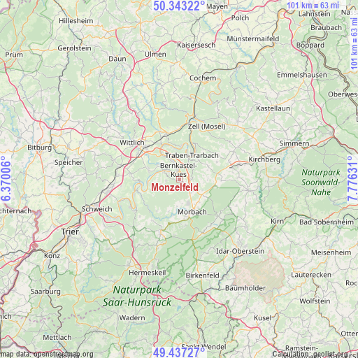
Monzelfeld GPS coordinates[2]
49° 53' 32.532" North, 7° 4' 23.448" East
| Map corner | latitude | longitude |
|---|---|---|
| Upper-left | 50.34322°, | 6.37006° |
| Center: | 49.89237°, | 7.07318° |
| Lower-right: | 49.43727°, | 7.77631° |
| Map W x H: | 100.7×100.7 km | = 62.6×62.6mi |
| max Lat: | 55.01917° ⇑66.7% North |
| Monzelfeld: | 49.89237° |
| min Lat: | ⇓33.3% South 47.40724° |
| min Long | Monzelfeld | max Long |
| 5.92978° | 7.07318° | 14.98853° |
| W 7.4%⇐ | ⇒92.6% E |
Elevation
Elevation of Monzelfeld is 443 m = 1453 ft, and this is 193.9 m = 636 ft above average elevation for this country.
| Max E: |
1256 m = 4121 ft | 18.6% |
| Monzelfeld | 443 m 1453 ft | |
| Avg. | 249.1 m = 817 ft | |
Min E: |
-5 m = -16 ft | 81.4% |
See also: Germany elevation on elevation.city.
Geographical zone
Monzelfeld is located in North temperate zone (between Tropic of Cancer and the Arctic Circle). Distance of this North polar circle is 1853.7 km =1151.8 mi to North.| Distance of | km | miles | from Monzelfeld |
|---|---|---|---|
| North Pole | 4459.6 | 2771.1 | to North |
| Arctic Circle | 1853.7 | 1151.8 | to North |
| Tropic Cancer | 2941.6 | 1827.8 | to South |
| Equator | 5547.5 | 3447.1 | to South |


Nearby cities:
15 places around Monzelfeld: (largest is in red/bold)
• Bernkastel-Kues
2.6 km =1.6 mi,  5°
5°
• Brauneberg
6.8 km =4.2 mi,  282°
282°
• Burgen
5.3 km =3.3 mi,  259°
259°
• Gornhausen
3.3 km =2.1 mi,  210°
210°
• Graach
4.7 km =2.9 mi,  351°
351°
• Kinheim
8.4 km =5.2 mi, 348°
• Kleinich
7.9 km =4.9 mi,  83°
83°
• Kommen
4.4 km =2.7 mi,  103°
103°
• Lieser
4.9 km =3 mi,  303°
303°
• Longkamp
3.2 km =2 mi,  93°
93°
• Maring-Noviand
6.9 km =4.3 mi,  310°
310°
• Mülheim
4.5 km =2.8 mi, 300°
• Traben-Trarbach
7.2 km =4.5 mi,  25°
25°
• Veldenz
3.7 km =2.3 mi, 263°
• Zeltingen-Rachtig
7.6 km =4.7 mi,  327°
327°
Sources, notices
• [Note1] Compared only with cities in Germany existing in our database
• [Src1] Map data: © OpenStreetMap contributors (CC-BY-SA)
• [Src2] Other city data from geonames.org with taken over terms of usage.
• [Src3] Geographical zone / Annual Mean Temperature by Robert A. Rohde @ Wikipedia
