Theeßen geodata
Theeßen (Saxony-Anhalt) is a populated place; located in Germany in Europe/Berlin (GMT+2) time zone. With population of 530 people, there are 9193 cities with bigger population in this country. Compared to other cities in Germany, 74.5% of cities are located further ↓South; 82.4% of cities are located further ←West and 76.7% of cities have higher elevation than Theeßen. Note1


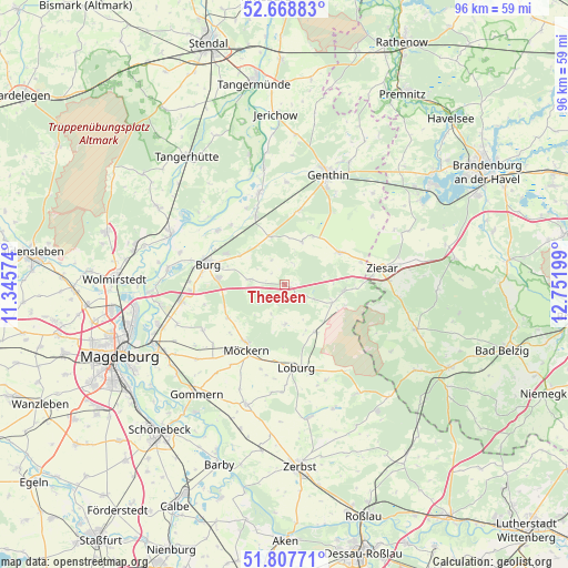
Theeßen GPS coordinates[2]
52° 14' 25.296" North, 12° 2' 55.896" East
| Map corner | latitude | longitude |
|---|---|---|
| Upper-left | 52.66883°, | 11.34574° |
| Center: | 52.24036°, | 12.04886° |
| Lower-right: | 51.80771°, | 12.75199° |
| Map W x H: | 95.7×95.7 km | = 59.5×59.5mi |
| max Lat: | 55.01917° ⇑25.5% North |
| Theeßen: | 52.24036° |
| min Lat: | ⇓74.5% South 47.40724° |
| min Long | Theeßen | max Long |
| 5.92978° | 12.04886° | 14.98853° |
| W 82.4%⇐ | ⇒17.6% E |
Elevation
Elevation of Theeßen is 57 m = 187 ft, and this is 192.1 m = 630 ft below average elevation for this country.
| Max E: |
1256 m = 4121 ft | 76.7% |
| Avg. | 249.1 m = 817 ft | |
| Theeßen | 57 m = 187 ft | |
Min E: |
-5 m = -16 ft | 23.3% |
See also: Germany elevation on elevation.city.
Geographical zone
Theeßen is located in North temperate zone (between Tropic of Cancer and the Arctic Circle). Distance of this North polar circle is 1592.6 km =989.6 mi to North.| Distance of | km | miles | from Theeßen |
|---|---|---|---|
| North Pole | 4198.5 | 2608.8 | to North |
| Arctic Circle | 1592.6 | 989.6 | to North |
| Tropic Cancer | 3202.7 | 1990.1 | to South |
| Equator | 5808.6 | 3609.3 | to South |


Nearby cities:
15 places around Theeßen: (largest is in red/bold)
• Burg bei Magdeburg
13.6 km =8.5 mi,  284°
284°
• Gladau
7.7 km =4.8 mi,  21°
21°
• Grabow
6 km =3.7 mi, 279°
• Hohenziatz
6.6 km =4.1 mi,  179°
179°
• Karow
18.7 km =11.6 mi,  51°
51°
• Loburg
14.1 km =8.8 mi,  171°
171°
• Möckern
12.9 km =8 mi,  210°
210°
• Möser
17.7 km =11 mi,  260°
260°
• Mützel
17.7 km =11 mi,  29°
29°
• Reesen
9 km =5.6 mi,  302°
302°
• Rosian
17.5 km =10.9 mi,  156°
156°
• Schermen
16 km =9.9 mi,  266°
266°
• Tucheim
10.7 km =6.6 mi,  59°
59°
• Zeppernick
12.9 km =8 mi,  188°
188°
• Ziesar
16.7 km =10.4 mi,  80°
80°
Sources, notices
• [Note1] Compared only with cities in Germany existing in our database
• [Src1] Map data: © OpenStreetMap contributors (CC-BY-SA)
• [Src2] Other city data from geonames.org with taken over terms of usage.
• [Src3] Geographical zone / Annual Mean Temperature by Robert A. Rohde @ Wikipedia
