Kalchreuth geodata
Kalchreuth (Bavaria) is a seat of a fourth-order administrative division; located in Germany in Europe/Berlin (GMT+2) time zone. With population of 3,031 people, there are 3975 cities with bigger population in this country. Compared to other cities in Germany, 74.6% of cities are located further ↑North; 68.9% of cities are located further ←West and 77.2% of cities have lower elevation than Kalchreuth. Note1
Administrative division(s):
- Level 1: Bavaria
- Level 2: Regierungsbezirk Mittelfranken
- Level 3: Landkreis Erlangen-Höchstadt
- Level 4: Kalchreuth


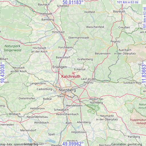
Kalchreuth GPS coordinates[2]
49° 33' 28.26" North, 11° 8' 0.6" East
| Map corner | latitude | longitude |
|---|---|---|
| Upper-left | 50.01183°, | 10.43038° |
| Center: | 49.55785°, | 11.1335° |
| Lower-right: | 49.09962°, | 11.83663° |
| Map W x H: | 101.4×101.4 km | = 63×63mi |
| max Lat: | 55.01917° ⇑74.6% North |
| Kalchreuth: | 49.55785° |
| min Lat: | ⇓25.4% South 47.40724° |
| min Long | Kalchreuth | max Long |
| 5.92978° | 11.1335° | 14.98853° |
| W 68.9%⇐ | ⇒31.1% E |
Elevation
Elevation of Kalchreuth is 414 m = 1358 ft, and this is 164.9 m = 541 ft above average elevation for this country.
| Max E: |
1256 m = 4121 ft | 22.8% |
| Kalchreuth | 414 m 1358 ft | |
| Avg. | 249.1 m = 817 ft | |
Min E: |
-5 m = -16 ft | 77.2% |
See also: Germany elevation on elevation.city.
Geographical zone
Kalchreuth is located in North temperate zone (between Tropic of Cancer and the Arctic Circle). Distance of this North polar circle is 1890.9 km =1175 mi to North.| Distance of | km | miles | from Kalchreuth |
|---|---|---|---|
| North Pole | 4496.7 | 2794.1 | to North |
| Arctic Circle | 1890.9 | 1175 | to North |
| Tropic Cancer | 2904.4 | 1804.7 | to South |
| Equator | 5510.3 | 3423.9 | to South |


Nearby cities:
15 places around Kalchreuth: (largest is in red/bold)
• Buckenhof
7.2 km =4.5 mi,  303°
303°
• Dormitz
4.6 km =2.9 mi,  345°
345°
• Erlangen
9.8 km =6.1 mi,  292°
292°
• Heroldsberg
3.2 km =2 mi,  150°
150°
• Hetzles
8.4 km =5.2 mi,  359°
359°
• Igensdorf
10.1 km =6.3 mi,  44°
44°
• Kleinsendelbach
4.5 km =2.8 mi,  22°
22°
• Langensendelbach
10.2 km =6.3 mi,  333°
333°
• Marloffstein
8.4 km =5.2 mi,  322°
322°
• Neunkirchen am Brand
6 km =3.7 mi, 357°
• Röthenbach an der Pegnitz
11.4 km =7.1 mi,  136°
136°
• Rückersdorf
10.6 km =6.6 mi,  129°
129°
• Schwaig
10.9 km =6.8 mi, 153°
• Spardorf
7.9 km =4.9 mi, 315°
• Uttenreuth
6.2 km =3.9 mi,  314°
314°
Sources, notices
• [Note1] Compared only with cities in Germany existing in our database
• [Src1] Map data: © OpenStreetMap contributors (CC-BY-SA)
• [Src2] Other city data from geonames.org with taken over terms of usage.
• [Src3] Geographical zone / Annual Mean Temperature by Robert A. Rohde @ Wikipedia
