Buchholz geodata
Buchholz (Schleswig-Holstein) is a seat of a fourth-order administrative division; located in Germany in Europe/Berlin (GMT+2) time zone. With population of 227 people, there are 10362 cities with bigger population in this country. Compared to other cities in Germany, 89.1% of cities are located further ↓South; 63.2% of cities are located further ←West and 96.2% of cities have higher elevation than Buchholz. Note1
Administrative division(s):
- Level 1: Schleswig-Holstein
- Level 3: Kreis Herzogtum Lauenburg
- Level 4: Buchholz


Buchholz GPS coordinates[2]
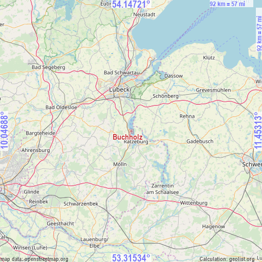
53° 43' 59.988" North, 10° 45' 0" East
| Map corner | latitude | longitude |
|---|---|---|
| Upper-left | 54.14721°, | 10.04688° |
| Center: | 53.73333°, | 10.75° |
| Lower-right: | 53.31534°, | 11.45313° |
| Map W x H: | 92.5×92.5 km | = 57.5×57.5mi |
| max Lat: | 55.01917° ⇑10.9% North |
| Buchholz: | 53.73333° |
| min Lat: | ⇓89.1% South 47.40724° |
| min Long | Buchholz | max Long |
| 5.92978° | 10.75° | 14.98853° |
| W 63.2%⇐ | ⇒36.8% E |
Elevation
Elevation of Buchholz is 6 m = 20 ft, and this is 243.1 m = 798 ft below average elevation for this country.
| Max E: |
1256 m = 4121 ft | 96.2% |
| Avg. | 249.1 m = 817 ft | |
| Buchholz | 6 m = 20 ft | |
Min E: |
-5 m = -16 ft | 3.8% |
See also: Germany elevation on elevation.city.
Geographical zone
Buchholz is located in North temperate zone (between Tropic of Cancer and the Arctic Circle). Distance of this North polar circle is 1426.6 km =886.4 mi to North.| Distance of | km | miles | from Buchholz |
|---|---|---|---|
| North Pole | 4032.5 | 2505.7 | to North |
| Arctic Circle | 1426.6 | 886.4 | to North |
| Tropic Cancer | 3368.7 | 2093.2 | to South |
| Equator | 5974.6 | 3712.4 | to South |


Nearby cities:
15 places around Buchholz: (largest is in red/bold)
• Albsfelde
6.5 km =4 mi,  210°
210°
• Behlendorf
6.6 km =4.1 mi,  235°
235°
• Bäk
2.9 km =1.8 mi,  130°
130°
• Einhaus
2.2 km =1.4 mi, 210°
• Giesensdorf
6.5 km =4 mi, 210°
• Groß Disnack
4.8 km =3 mi,  292°
292°
• Groß Sarau
3.9 km =2.4 mi,  343°
343°
• Harmsdorf
4.3 km =2.7 mi, 210°
• Kulpin
4.5 km =2.8 mi,  234°
234°
• Mechow
3.8 km =2.4 mi,  119°
119°
• Pogeez
2.4 km =1.5 mi,  324°
324°
• Ratzeburg
4 km =2.5 mi,  158°
158°
• Römnitz
2.2 km =1.4 mi,  149°
149°
• Schlagsdorf
5 km =3.1 mi,  89°
89°
• Ziethen
5.8 km =3.6 mi,  137°
137°
Sources, notices
• [Note1] Compared only with cities in Germany existing in our database
• [Src1] Map data: © OpenStreetMap contributors (CC-BY-SA)
• [Src2] Other city data from geonames.org with taken over terms of usage.
• [Src3] Geographical zone / Annual Mean Temperature by Robert A. Rohde @ Wikipedia
