Ratzeburg geodata
Ratzeburg (Schleswig-Holstein) is a seat of a third-order administrative division; located in Germany in Europe/Berlin (GMT+2) time zone. With population of 13,623 people, there are 1177 cities with bigger population in this country. Compared to other cities in Germany, 88.6% of cities are located further ↓South; 63.6% of cities are located further ←West and 93.1% of cities have higher elevation than Ratzeburg. Note1
Administrative division(s):
- Level 1: Schleswig-Holstein
- Level 3: Kreis Herzogtum Lauenburg
- Level 4: Ratzeburg


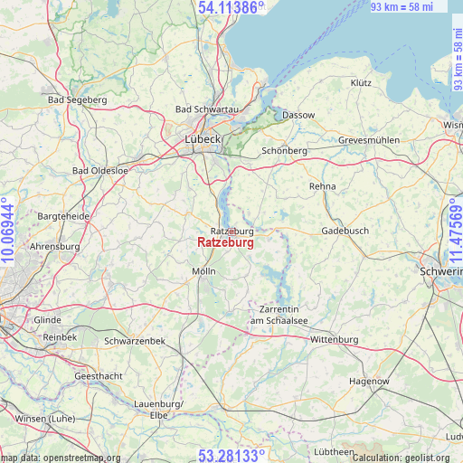
Ratzeburg GPS coordinates[2]
53° 41' 58.74" North, 10° 46' 21.216" East
| Map corner | latitude | longitude |
|---|---|---|
| Upper-left | 54.11386°, | 10.06944° |
| Center: | 53.69965°, | 10.77256° |
| Lower-right: | 53.28133°, | 11.47569° |
| Map W x H: | 92.6×92.6 km | = 57.5×57.5mi |
| max Lat: | 55.01917° ⇑11.4% North |
| Ratzeburg: | 53.69965° |
| min Lat: | ⇓88.6% South 47.40724° |
| min Long | Ratzeburg | max Long |
| 5.92978° | 10.77256° | 14.98853° |
| W 63.6%⇐ | ⇒36.4% E |
Elevation
Elevation of Ratzeburg is 13 m = 43 ft, and this is 236.1 m = 775 ft below average elevation for this country.
| Max E: |
1256 m = 4121 ft | 93.1% |
| Avg. | 249.1 m = 817 ft | |
| Ratzeburg | 13 m = 43 ft | |
Min E: |
-5 m = -16 ft | 6.9% |
See also: Germany elevation on elevation.city.
Geographical zone
Ratzeburg is located in North temperate zone (between Tropic of Cancer and the Arctic Circle). Distance of this North polar circle is 1430.3 km =888.7 mi to North.| Distance of | km | miles | from Ratzeburg |
|---|---|---|---|
| North Pole | 4036.2 | 2508 | to North |
| Arctic Circle | 1430.3 | 888.7 | to North |
| Tropic Cancer | 3364.9 | 2090.9 | to South |
| Equator | 5970.8 | 3710.1 | to South |


Nearby cities:
15 places around Ratzeburg: (largest is in red/bold)
• Albsfelde
5.1 km =3.2 mi,  249°
249°
• Buchholz
4 km =2.5 mi,  338°
338°
• Bäk
2 km =1.2 mi,  20°
20°
• Einhaus
3.2 km =2 mi,  306°
306°
• Fredeburg
5.2 km =3.2 mi,  225°
225°
• Giesensdorf
5.1 km =3.2 mi, 249°
• Harmsdorf
3.7 km =2.3 mi,  270°
270°
• Kulpin
5.2 km =3.2 mi,  282°
282°
• Mechow
2.6 km =1.6 mi,  43°
43°
• Pogeez
6.4 km =4 mi,  333°
333°
• Römnitz
1.9 km =1.2 mi,  348°
348°
• Salem
6 km =3.7 mi,  143°
143°
• Schlagsdorf
5.1 km =3.2 mi, 42°
• Schmilau
4.3 km =2.7 mi,  194°
194°
• Ziethen
2.5 km =1.6 mi,  103°
103°
In other languages:
- In Spanish: Ratzeburgo
- In France: Ratzebourg
- In Russian: Ратцебург
- In Chinese: 拉策堡
Sources, notices
• [Note1] Compared only with cities in Germany existing in our database
• [Src1] Map data: © OpenStreetMap contributors (CC-BY-SA)
• [Src2] Other city data from geonames.org with taken over terms of usage.
• [Src3] Geographical zone / Annual Mean Temperature by Robert A. Rohde @ Wikipedia
