Kulpin geodata
Kulpin (Schleswig-Holstein) is a seat of a fourth-order administrative division; located in Germany in Europe/Berlin (GMT+2) time zone. With population of 260 people, there are 10208 cities with bigger population in this country. Compared to other cities in Germany, 88.8% of cities are located further ↓South; 62.4% of cities are located further ←West and 81.4% of cities have higher elevation than Kulpin. Note1
Administrative division(s):
- Level 1: Schleswig-Holstein
- Level 3: Kreis Herzogtum Lauenburg
- Level 4: Kulpin


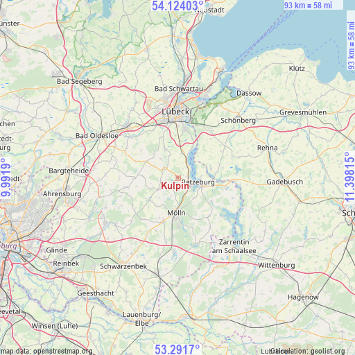
Kulpin GPS coordinates[2]
53° 42' 35.712" North, 10° 41' 42.072" East
| Map corner | latitude | longitude |
|---|---|---|
| Upper-left | 54.12403°, | 9.9919° |
| Center: | 53.70992°, | 10.69502° |
| Lower-right: | 53.2917°, | 11.39815° |
| Map W x H: | 92.5×92.5 km | = 57.5×57.5mi |
| max Lat: | 55.01917° ⇑11.2% North |
| Kulpin: | 53.70992° |
| min Lat: | ⇓88.8% South 47.40724° |
| min Long | Kulpin | max Long |
| 5.92978° | 10.69502° | 14.98853° |
| W 62.4%⇐ | ⇒37.6% E |
Elevation
Elevation of Kulpin is 43 m = 141 ft, and this is 206.1 m = 676 ft below average elevation for this country.
| Max E: |
1256 m = 4121 ft | 81.4% |
| Avg. | 249.1 m = 817 ft | |
| Kulpin | 43 m = 141 ft | |
Min E: |
-5 m = -16 ft | 18.6% |
See also: Germany elevation on elevation.city.
Geographical zone
Kulpin is located in North temperate zone (between Tropic of Cancer and the Arctic Circle). Distance of this North polar circle is 1429.2 km =888.1 mi to North.| Distance of | km | miles | from Kulpin |
|---|---|---|---|
| North Pole | 4035.1 | 2507.3 | to North |
| Arctic Circle | 1429.2 | 888.1 | to North |
| Tropic Cancer | 3366.1 | 2091.6 | to South |
| Equator | 5972 | 3710.8 | to South |


Nearby cities:
15 places around Kulpin: (largest is in red/bold)
• Albsfelde
3 km =1.9 mi,  173°
173°
• Behlendorf
2.2 km =1.4 mi,  239°
239°
• Berkenthin
3.9 km =2.4 mi,  311°
311°
• Buchholz
4.5 km =2.8 mi,  54°
54°
• Bäk
5.9 km =3.7 mi,  82°
82°
• Einhaus
2.6 km =1.6 mi,  73°
73°
• Fredeburg
5 km =3.1 mi,  163°
163°
• Giesensdorf
3 km =1.9 mi, 173°
• Groß Disnack
4.5 km =2.8 mi,  350°
350°
• Göldenitz
4.1 km =2.5 mi,  280°
280°
• Harmsdorf
1.8 km =1.1 mi,  127°
127°
• Lankau
5.2 km =3.2 mi,  201°
201°
• Pogeez
5.1 km =3.2 mi,  25°
25°
• Ratzeburg
5.2 km =3.2 mi,  102°
102°
• Römnitz
4.8 km =3 mi, 80°
Sources, notices
• [Note1] Compared only with cities in Germany existing in our database
• [Src1] Map data: © OpenStreetMap contributors (CC-BY-SA)
• [Src2] Other city data from geonames.org with taken over terms of usage.
• [Src3] Geographical zone / Annual Mean Temperature by Robert A. Rohde @ Wikipedia
