Brachbach geodata
Brachbach (Rheinland-Pfalz) is a seat of a fourth-order administrative division; located in Germany in Europe/Berlin (GMT+2) time zone. With population of 2,458 people, there are 4491 cities with bigger population in this country. Compared to other cities in Germany, 54.4% of cities are located further ↓South; 78.5% of cities are located further →East and 50.2% of cities have higher elevation than Brachbach. Note1
Administrative division(s):
- Level 1: Rheinland-Pfalz
- Level 3: Landkreis Altenkirchen
- Level 4: Brachbach


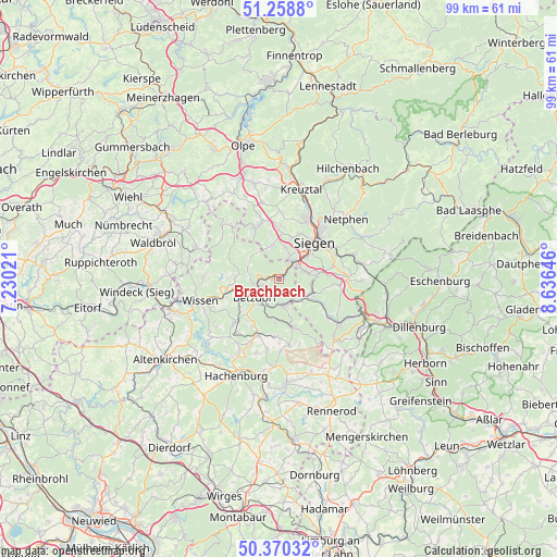
Brachbach GPS coordinates[2]
50° 49' 0.012" North, 7° 55' 59.988" East
| Map corner | latitude | longitude |
|---|---|---|
| Upper-left | 51.2588°, | 7.23021° |
| Center: | 50.81667°, | 7.93333° |
| Lower-right: | 50.37032°, | 8.63646° |
| Map W x H: | 98.8×98.8 km | = 61.4×61.4mi |
| max Lat: | 55.01917° ⇑45.6% North |
| Brachbach: | 50.81667° |
| min Lat: | ⇓54.4% South 47.40724° |
| min Long | Brachbach | max Long |
| 5.92978° | 7.93333° | 14.98853° |
| W 21.5%⇐ | ⇒78.5% E |
Elevation
Elevation of Brachbach is 224 m = 735 ft, and this is 25.1 m = 82 ft below average elevation for this country.
| Max E: |
1256 m = 4121 ft | 50.2% |
| Avg. | 249.1 m = 817 ft | |
| Brachbach | 224 m = 735 ft | |
Min E: |
-5 m = -16 ft | 49.8% |
See also: Germany elevation on elevation.city.
Geographical zone
Brachbach is located in North temperate zone (between Tropic of Cancer and the Arctic Circle). Distance of this North polar circle is 1750.9 km =1088 mi to North.| Distance of | km | miles | from Brachbach |
|---|---|---|---|
| North Pole | 4356.8 | 2707.2 | to North |
| Arctic Circle | 1750.9 | 1088 | to North |
| Tropic Cancer | 3044.4 | 1891.7 | to South |
| Equator | 5650.3 | 3510.9 | to South |


Nearby cities:
15 places around Brachbach: (largest is in red/bold)
• Alsdorf
5.5 km =3.4 mi,  217°
217°
• Betzdorf
5.2 km =3.2 mi,  236°
236°
• Grünebach
4.4 km =2.7 mi,  212°
212°
• Harbach
7.9 km =4.9 mi,  297°
297°
• Herdorf
4.6 km =2.9 mi,  162°
162°
• Katzwinkel
7.8 km =4.8 mi,  268°
268°
• Kirchen
3.4 km =2.1 mi,  254°
254°
• Mudersbach
1.2 km =0.7 mi,  37°
37°
• Neunkirchen
5 km =3.1 mi,  111°
111°
• Niederdreisbach
7.5 km =4.7 mi,  185°
185°
• Niederfischbach
6 km =3.7 mi,  308°
308°
• Scheuerfeld
7.2 km =4.5 mi, 243°
• Schutzbach
7.8 km =4.8 mi,  197°
197°
• Steineroth
8.4 km =5.2 mi, 221°
• Wallmenroth
7.3 km =4.5 mi,  255°
255°
Sources, notices
• [Note1] Compared only with cities in Germany existing in our database
• [Src1] Map data: © OpenStreetMap contributors (CC-BY-SA)
• [Src2] Other city data from geonames.org with taken over terms of usage.
• [Src3] Geographical zone / Annual Mean Temperature by Robert A. Rohde @ Wikipedia
