Niederfischbach geodata
Niederfischbach (Rheinland-Pfalz) is a seat of a fourth-order administrative division; located in Germany in Europe/Berlin (GMT+2) time zone. With population of 5,035 people, there are 2813 cities with bigger population in this country. Compared to other cities in Germany, 55% of cities are located further ↓South; 79.7% of cities are located further →East and 61.1% of cities have lower elevation than Niederfischbach. Note1
Administrative division(s):
- Level 1: Rheinland-Pfalz
- Level 3: Landkreis Altenkirchen
- Level 4: Niederfischbach


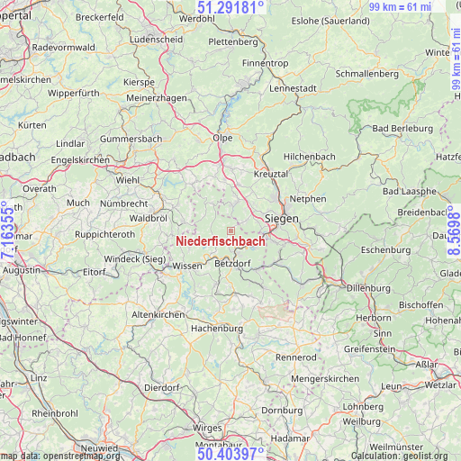
Niederfischbach GPS coordinates[2]
50° 51' 0" North, 7° 52' 0.012" East
| Map corner | latitude | longitude |
|---|---|---|
| Upper-left | 51.29181°, | 7.16355° |
| Center: | 50.85°, | 7.86667° |
| Lower-right: | 50.40397°, | 8.5698° |
| Map W x H: | 98.7×98.7 km | = 61.3×61.3mi |
| max Lat: | 55.01917° ⇑45% North |
| Niederfischbach: | 50.85° |
| min Lat: | ⇓55% South 47.40724° |
| min Long | Niederfischbach | max Long |
| 5.92978° | 7.86667° | 14.98853° |
| W 20.3%⇐ | ⇒79.7% E |
Elevation
Elevation of Niederfischbach is 296 m = 971 ft, and this is 46.9 m = 154 ft above average elevation for this country.
| Max E: |
1256 m = 4121 ft | 38.9% |
| Niederfischbach | 296 m 971 ft | |
| Avg. | 249.1 m = 817 ft | |
Min E: |
-5 m = -16 ft | 61.1% |
See also: Germany elevation on elevation.city.
Geographical zone
Niederfischbach is located in North temperate zone (between Tropic of Cancer and the Arctic Circle). Distance of this North polar circle is 1747.2 km =1085.7 mi to North.| Distance of | km | miles | from Niederfischbach |
|---|---|---|---|
| North Pole | 4353.1 | 2704.9 | to North |
| Arctic Circle | 1747.2 | 1085.7 | to North |
| Tropic Cancer | 3048.1 | 1894 | to South |
| Equator | 5654 | 3513.2 | to South |


Nearby cities:
15 places around Niederfischbach: (largest is in red/bold)
• Alsdorf
8.2 km =5.1 mi,  170°
170°
• Betzdorf
6.6 km =4.1 mi,  176°
176°
• Brachbach
6 km =3.7 mi,  128°
128°
• Freudenberg
5.3 km =3.3 mi,  5°
5°
• Friesenhagen
7.2 km =4.5 mi,  326°
326°
• Grünebach
7.8 km =4.8 mi,  162°
162°
• Harbach
2.3 km =1.4 mi,  270°
270°
• Katzwinkel
5 km =3.1 mi,  218°
218°
• Kirchen
4.8 km =3 mi, 163°
• Mittelhof
9.4 km =5.8 mi,  207°
207°
• Morsbach
9.9 km =6.2 mi,  280°
280°
• Mudersbach
6.1 km =3.8 mi,  117°
117°
• Scheuerfeld
7.2 km =4.5 mi,  194°
194°
• Steineroth
10 km =6.2 mi, 184°
• Wallmenroth
6 km =3.7 mi,  202°
202°
Sources, notices
• [Note1] Compared only with cities in Germany existing in our database
• [Src1] Map data: © OpenStreetMap contributors (CC-BY-SA)
• [Src2] Other city data from geonames.org with taken over terms of usage.
• [Src3] Geographical zone / Annual Mean Temperature by Robert A. Rohde @ Wikipedia
