Bötersen geodata
Bötersen (Lower Saxony) is a seat of a fourth-order administrative division; located in Germany in Europe/Berlin (GMT+2) time zone. With population of 1,055 people, there are 6986 cities with bigger population in this country. Compared to other cities in Germany, 82.4% of cities are located further ↓South; 60.6% of cities are located further →East and 85.8% of cities have higher elevation than Bötersen. Note1


Bötersen GPS coordinates[2]
53° 7' 59.988" North, 9° 19' 0.012" East
| Map corner | latitude | longitude |
|---|---|---|
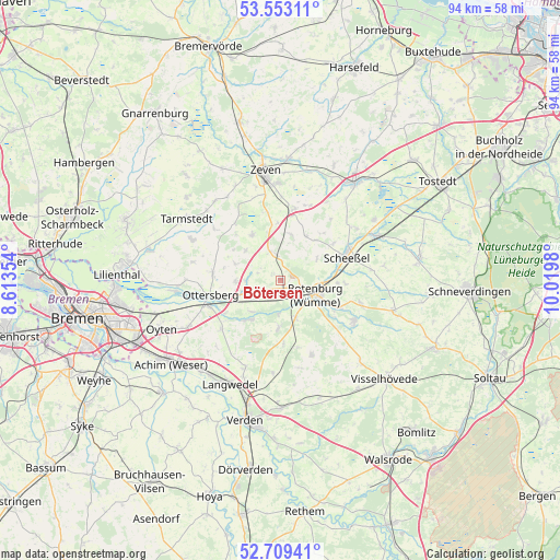
| Upper-left | 53.55311°, | 8.61354° |
| Center: | 53.13333°, | 9.31667° |
| Lower-right: | 52.70941°, | 10.0198° |
| Map W x H: | 93.8×93.8 km | = 58.3×58.3mi |
| max Lat: | 55.01917° ⇑17.6% North |
| Bötersen: | 53.13333° |
| min Lat: | ⇓82.4% South 47.40724° |
| min Long | Bötersen | max Long |
| 5.92978° | 9.31667° | 14.98853° |
| W 39.4%⇐ | ⇒60.6% E |
Elevation
Elevation of Bötersen is 33 m = 108 ft, and this is 216.1 m = 709 ft below average elevation for this country.
| Max E: |
1256 m = 4121 ft | 85.8% |
| Avg. | 249.1 m = 817 ft | |
| Bötersen | 33 m = 108 ft | |
Min E: |
-5 m = -16 ft | 14.2% |
See also: Germany elevation on elevation.city.
Geographical zone
Bötersen is located in North temperate zone (between Tropic of Cancer and the Arctic Circle). Distance of this North polar circle is 1493.3 km =927.9 mi to North.| Distance of | km | miles | from Bötersen |
|---|---|---|---|
| North Pole | 4099.2 | 2547.1 | to North |
| Arctic Circle | 1493.3 | 927.9 | to North |
| Tropic Cancer | 3302 | 2051.8 | to South |
| Equator | 5907.9 | 3671 | to South |


Nearby cities:
15 places around Bötersen: (largest is in red/bold)
• Ahausen
7.4 km =4.6 mi,  180°
180°
• Brockel
13.9 km =8.6 mi,  105°
105°
• Elsdorf
12.2 km =7.6 mi,  10°
10°
• Gyhum
9.3 km =5.8 mi,  0°
0°
• Hassendorf
4.4 km =2.7 mi,  231°
231°
• Hellwege
8.6 km =5.3 mi,  219°
219°
• Hemsbünde
11.5 km =7.1 mi, 114°
• Horstedt
7.9 km =4.9 mi,  315°
315°
• Ottersberg
11.8 km =7.3 mi,  257°
257°
• Reeßum
6.7 km =4.2 mi,  270°
270°
• Rotenburg
6.7 km =4.2 mi, 111°
• Scheeßel
11.7 km =7.3 mi,  71°
71°
• Sottrum
5.9 km =3.7 mi,  251°
251°
• Vorwerk
12.4 km =7.7 mi,  296°
296°
• Westerwalsede
11.6 km =7.2 mi,  163°
163°
Sources, notices
• [Note1] Compared only with cities in Germany existing in our database
• [Src1] Map data: © OpenStreetMap contributors (CC-BY-SA)
• [Src2] Other city data from geonames.org with taken over terms of usage.
• [Src3] Geographical zone / Annual Mean Temperature by Robert A. Rohde @ Wikipedia
