Hellwege geodata
Hellwege (Lower Saxony) is a seat of a fourth-order administrative division; located in Germany in Europe/Berlin (GMT+2) time zone. With population of 1,083 people, there are 6897 cities with bigger population in this country. Compared to other cities in Germany, 82.1% of cities are located further ↓South; 61.7% of cities are located further →East and 91.2% of cities have higher elevation than Hellwege. Note1


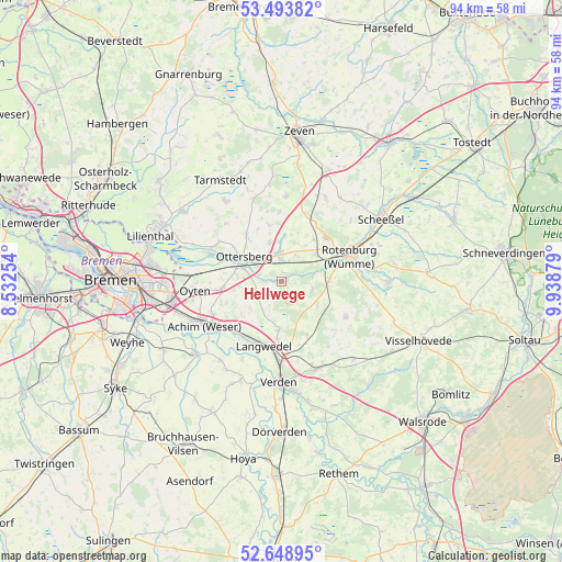
Hellwege GPS coordinates[2]
53° 4' 24.456" North, 9° 14' 8.376" East
| Map corner | latitude | longitude |
|---|---|---|
| Upper-left | 53.49382°, | 8.53254° |
| Center: | 53.07346°, | 9.23566° |
| Lower-right: | 52.64895°, | 9.93879° |
| Map W x H: | 93.9×93.9 km | = 58.3×58.3mi |
| max Lat: | 55.01917° ⇑17.9% North |
| Hellwege: | 53.07346° |
| min Lat: | ⇓82.1% South 47.40724° |
| min Long | Hellwege | max Long |
| 5.92978° | 9.23566° | 14.98853° |
| W 38.3%⇐ | ⇒61.7% E |
Elevation
Elevation of Hellwege is 18 m = 59 ft, and this is 231.1 m = 758 ft below average elevation for this country.
| Max E: |
1256 m = 4121 ft | 91.2% |
| Avg. | 249.1 m = 817 ft | |
| Hellwege | 18 m = 59 ft | |
Min E: |
-5 m = -16 ft | 8.8% |
See also: Germany elevation on elevation.city.
Geographical zone
Hellwege is located in North temperate zone (between Tropic of Cancer and the Arctic Circle). Distance of this North polar circle is 1500 km =932.1 mi to North.| Distance of | km | miles | from Hellwege |
|---|---|---|---|
| North Pole | 4105.8 | 2551.2 | to North |
| Arctic Circle | 1500 | 932.1 | to North |
| Tropic Cancer | 3295.3 | 2047.6 | to South |
| Equator | 5901.2 | 3666.8 | to South |


Nearby cities:
15 places around Hellwege: (largest is in red/bold)
• Achim
15.5 km =9.6 mi,  244°
244°
• Ahausen
5.5 km =3.4 mi,  97°
97°
• Bötersen
8.6 km =5.3 mi,  39°
39°
• Hassendorf
4.4 km =2.7 mi,  26°
26°
• Horstedt
12.2 km =7.6 mi,  359°
359°
• Kirchwalsede
12.7 km =7.9 mi,  119°
119°
• Langwedel
11.1 km =6.9 mi,  197°
197°
• Ottersberg
7.3 km =4.5 mi,  303°
303°
• Oyten
14.9 km =9.3 mi,  259°
259°
• Reeßum
6.8 km =4.2 mi,  349°
349°
• Rotenburg
12.4 km =7.7 mi,  70°
70°
• Scharnhorst
13.6 km =8.5 mi,  168°
168°
• Sottrum
4.8 km =3 mi, 358°
• Vorwerk
13.5 km =8.4 mi,  334°
334°
• Westerwalsede
9.8 km =6.1 mi, 117°
Sources, notices
• [Note1] Compared only with cities in Germany existing in our database
• [Src1] Map data: © OpenStreetMap contributors (CC-BY-SA)
• [Src2] Other city data from geonames.org with taken over terms of usage.
• [Src3] Geographical zone / Annual Mean Temperature by Robert A. Rohde @ Wikipedia
