Damsdorf geodata
Damsdorf (Schleswig-Holstein) is a seat of a fourth-order administrative division; located in Germany in Europe/Berlin (GMT+2) time zone. With population of 259 people, there are 10213 cities with bigger population in this country. Compared to other cities in Germany, 93.4% of cities are located further ↓South; 55.7% of cities are located further ←West and 76.7% of cities have higher elevation than Damsdorf. Note1


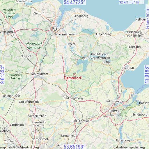
Damsdorf GPS coordinates[2]
54° 4' 0.012" North, 10° 19' 0.012" East
| Map corner | latitude | longitude |
|---|---|---|
| Upper-left | 54.47725°, | 9.61354° |
| Center: | 54.06667°, | 10.31667° |
| Lower-right: | 53.65199°, | 11.0198° |
| Map W x H: | 91.8×91.8 km | = 57×57mi |
| max Lat: | 55.01917° ⇑6.6% North |
| Damsdorf: | 54.06667° |
| min Lat: | ⇓93.4% South 47.40724° |
| min Long | Damsdorf | max Long |
| 5.92978° | 10.31667° | 14.98853° |
| W 55.7%⇐ | ⇒44.3% E |
Elevation
Elevation of Damsdorf is 57 m = 187 ft, and this is 192.1 m = 630 ft below average elevation for this country.
| Max E: |
1256 m = 4121 ft | 76.7% |
| Avg. | 249.1 m = 817 ft | |
| Damsdorf | 57 m = 187 ft | |
Min E: |
-5 m = -16 ft | 23.3% |
See also: Germany elevation on elevation.city.
Geographical zone
Damsdorf is located in North temperate zone (between Tropic of Cancer and the Arctic Circle). Distance of this North polar circle is 1389.5 km =863.4 mi to North.| Distance of | km | miles | from Damsdorf |
|---|---|---|---|
| North Pole | 3995.4 | 2482.6 | to North |
| Arctic Circle | 1389.5 | 863.4 | to North |
| Tropic Cancer | 3405.7 | 2116.2 | to South |
| Equator | 6011.7 | 3735.5 | to South |


Nearby cities:
15 places around Damsdorf: (largest is in red/bold)
• Belau
5.2 km =3.2 mi,  312°
312°
• Blunk
6.4 km =4 mi,  181°
181°
• Bornhöved
5.4 km =3.4 mi,  270°
270°
• Daldorf
7.1 km =4.4 mi,  218°
218°
• Dersau
5.8 km =3.6 mi,  10°
10°
• Kalübbe
6 km =3.7 mi,  338°
338°
• Nehms
6.4 km =4 mi,  149°
149°
• Nehmten
6.6 km =4.1 mi,  55°
55°
• Ruhwinkel
7.5 km =4.7 mi,  299°
299°
• Schmalensee
3.5 km =2.2 mi, 301°
• Seedorf
6.8 km =4.2 mi,  105°
105°
• Stocksee
3.1 km =1.9 mi,  32°
32°
• Tarbek
3.8 km =2.4 mi,  240°
240°
• Tensfeld
2.7 km =1.7 mi, 177°
• Trappenkamp
7.3 km =4.5 mi,  245°
245°
Sources, notices
• [Note1] Compared only with cities in Germany existing in our database
• [Src1] Map data: © OpenStreetMap contributors (CC-BY-SA)
• [Src2] Other city data from geonames.org with taken over terms of usage.
• [Src3] Geographical zone / Annual Mean Temperature by Robert A. Rohde @ Wikipedia
