Steinheim am Albuch geodata
Steinheim am Albuch (Baden-Württemberg) is a seat of a fourth-order administrative division; located in Germany in Europe/Berlin (GMT+2) time zone. With population of 9,013 people, there are 1786 cities with bigger population in this country. Compared to other cities in Germany, 86.6% of cities are located further ↑North; 51.1% of cities are located further ←West and 91.4% of cities have lower elevation than Steinheim am Albuch. Note1
Administrative division(s):
- Level 1: Baden-Württemberg
- Level 2: Regierungsbezirk Stuttgart
- Level 3: Landkreis Heidenheim
- Level 4: Steinheim am Albuch


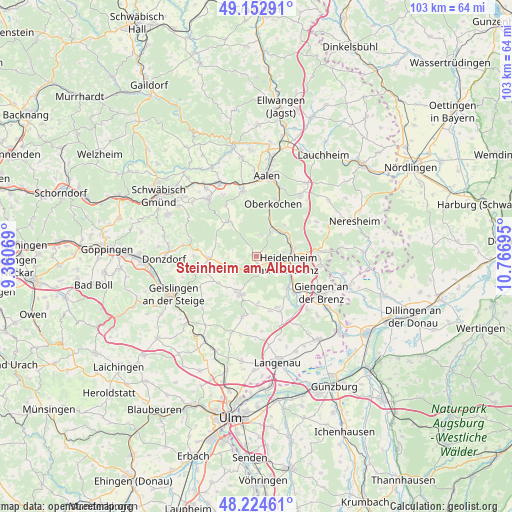
Steinheim am Albuch GPS coordinates[2]
48° 41' 27.24" North, 10° 3' 49.752" East
| Map corner | latitude | longitude |
|---|---|---|
| Upper-left | 49.15291°, | 9.36069° |
| Center: | 48.6909°, | 10.06382° |
| Lower-right: | 48.22461°, | 10.76695° |
| Map W x H: | 103.2×103.2 km | = 64.1×64.1mi |
| max Lat: | 55.01917° ⇑86.6% North |
| Steinheim am Albuch: | 48.6909° |
| min Lat: | ⇓13.4% South 47.40724° |
| min Long | Steinheim am Al | max Long |
| 5.92978° | 10.06382° | 14.98853° |
| W 51.1%⇐ | ⇒48.9% E |
Elevation
Elevation of Steinheim am Albuch is 534 m = 1752 ft, and this is 284.9 m = 935 ft above average elevation for this country.
| Max E: |
1256 m = 4121 ft | 8.6% |
| Steinheim am Albuch | 534 m 1752 ft | |
| Avg. | 249.1 m = 817 ft | |
Min E: |
-5 m = -16 ft | 91.4% |
See also: Germany elevation on elevation.city.
Geographical zone
Steinheim am Albuch is located in North temperate zone (between Tropic of Cancer and the Arctic Circle). Distance of this North polar circle is 1987.3 km =1234.9 mi to North.| Distance of | km | miles | from Steinheim am Albuch |
|---|---|---|---|
| North Pole | 4593.1 | 2854 | to North |
| Arctic Circle | 1987.3 | 1234.9 | to North |
| Tropic Cancer | 2808 | 1744.8 | to South |
| Equator | 5413.9 | 3364 | to South |


Nearby cities:
15 places around Steinheim am Albuch: (largest is in red/bold)
• Ballendorf
15.2 km =9.4 mi,  176°
176°
• Bartholomä
8.9 km =5.5 mi,  321°
321°
• Bolheim
9.2 km =5.7 mi,  136°
136°
• Böhmenkirch
9.6 km =6 mi,  264°
264°
• Essingen
13.4 km =8.3 mi,  348°
348°
• Gerstetten
8.3 km =5.2 mi,  203°
203°
• Giengen an der Brenz
15.2 km =9.4 mi,  120°
120°
• Heidenheim an der Brenz
6.6 km =4.1 mi,  102°
102°
• Herbrechtingen
11.3 km =7 mi,  133°
133°
• Heubach
14.8 km =9.2 mi, 319°
• Königsbronn
6.8 km =4.2 mi,  31°
31°
• Nattheim
13.1 km =8.1 mi,  85°
85°
• Neenstetten
16.3 km =10.1 mi,  191°
191°
• Oberkochen
10.8 km =6.7 mi,  16°
16°
• Weidenstetten
16.2 km =10.1 mi, 197°
Sources, notices
• [Note1] Compared only with cities in Germany existing in our database
• [Src1] Map data: © OpenStreetMap contributors (CC-BY-SA)
• [Src2] Other city data from geonames.org with taken over terms of usage.
• [Src3] Geographical zone / Annual Mean Temperature by Robert A. Rohde @ Wikipedia
