Bocholt geodata
Bocholt (North Rhine-Westphalia) is a populated place; located in Germany in Europe/Berlin (GMT+2) time zone. With population of 73,943 people, there are 142 cities with bigger population in this country. Compared to other cities in Germany, 70.4% of cities are located further ↓South; 97% of cities are located further →East and 86.6% of cities have higher elevation than Bocholt. Note1
Administrative division(s):
- Level 1: North Rhine-Westphalia
- Level 2: Regierungsbezirk Münster
- Level 3: Kreis Borken
- Level 4: Bocholt


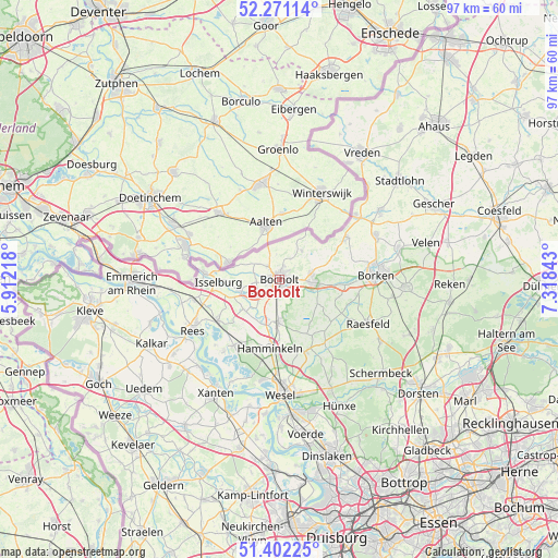
Bocholt GPS coordinates[2]
51° 50' 19.644" North, 6° 36' 55.116" East
| Map corner | latitude | longitude |
|---|---|---|
| Upper-left | 52.27114°, | 5.91218° |
| Center: | 51.83879°, | 6.61531° |
| Lower-right: | 51.40225°, | 7.31843° |
| Map W x H: | 96.6×96.6 km | = 60×60mi |
| max Lat: | 55.01917° ⇑29.6% North |
| Bocholt: | 51.83879° |
| min Lat: | ⇓70.4% South 47.40724° |
| min Long | Bocholt | max Long |
| 5.92978° | 6.61531° | 14.98853° |
| W 3%⇐ | ⇒97% E |
Elevation
Elevation of Bocholt is 31 m = 102 ft, and this is 218.1 m = 716 ft below average elevation for this country.
| Max E: |
1256 m = 4121 ft | 86.6% |
| Avg. | 249.1 m = 817 ft | |
| Bocholt | 31 m = 102 ft | |
Min E: |
-5 m = -16 ft | 13.4% |
See also: Bocholt elevation on elevation.city.
Geographical zone
Bocholt is located in North temperate zone (between Tropic of Cancer and the Arctic Circle). Distance of this North polar circle is 1637.2 km =1017.3 mi to North.| Distance of | km | miles | from Bocholt |
|---|---|---|---|
| North Pole | 4243.1 | 2636.5 | to North |
| Arctic Circle | 1637.2 | 1017.3 | to North |
| Tropic Cancer | 3158 | 1962.3 | to South |
| Equator | 5763.9 | 3581.5 | to South |


Nearby cities:
15 places around Bocholt: (largest is in red/bold)
• Borken
16.7 km =10.4 mi,  88°
88°
• Emmerich
25.2 km =15.7 mi,  270°
270°
• Hamminkeln
11.9 km =7.4 mi,  188°
188°
• Heiden
21.9 km =13.6 mi, 91°
• Hünxe
23.5 km =14.6 mi,  166°
166°
• Isselburg
10.4 km =6.5 mi, 266°
• Kalkar
24.9 km =15.5 mi,  243°
243°
• Mehrhoog
13.3 km =8.3 mi,  212°
212°
• Raesfeld
18 km =11.2 mi,  116°
116°
• Rees
17.2 km =10.7 mi, 240°
• Rhede
5.6 km =3.5 mi, 93°
• Schermbeck
24.5 km =15.2 mi,  134°
134°
• Südlohn
20.2 km =12.6 mi,  58°
58°
• Wesel
19.1 km =11.9 mi,  178°
178°
• Xanten
22.9 km =14.2 mi, 209°
Sources, notices
• [Note1] Compared only with cities in Germany existing in our database
• [Src1] Map data: © OpenStreetMap contributors (CC-BY-SA)
• [Src2] Other city data from geonames.org with taken over terms of usage.
• [Src3] Geographical zone / Annual Mean Temperature by Robert A. Rohde @ Wikipedia
