Hünxe geodata
Hünxe (North Rhine-Westphalia) is a seat of a fourth-order administrative division; located in Germany in Europe/Berlin (GMT+2) time zone. With population of 13,732 people, there are 1168 cities with bigger population in this country. Compared to other cities in Germany, 68.1% of cities are located further ↓South; 96.4% of cities are located further →East and 88.6% of cities have higher elevation than Hünxe. Note1
Administrative division(s):
- Level 1: North Rhine-Westphalia
- Level 2: Düsseldorf District
- Level 3: Kreis Wesel
- Level 4: Hünxe


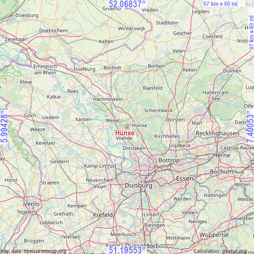
Hünxe GPS coordinates[2]
51° 38' 2.58" North, 6° 41' 50.676" East
| Map corner | latitude | longitude |
|---|---|---|
| Upper-left | 52.06837°, | 5.99428° |
| Center: | 51.63405°, | 6.69741° |
| Lower-right: | 51.19553°, | 7.40053° |
| Map W x H: | 97.1×97 km | = 60.3×60.3mi |
| max Lat: | 55.01917° ⇑31.9% North |
| Hünxe: | 51.63405° |
| min Lat: | ⇓68.1% South 47.40724° |
| min Long | Hünxe | max Long |
| 5.92978° | 6.69741° | 14.98853° |
| W 3.6%⇐ | ⇒96.4% E |
Elevation
Elevation of Hünxe is 25 m = 82 ft, and this is 224.1 m = 735 ft below average elevation for this country.
| Max E: |
1256 m = 4121 ft | 88.6% |
| Avg. | 249.1 m = 817 ft | |
| Hünxe | 25 m = 82 ft | |
Min E: |
-5 m = -16 ft | 11.4% |
See also: Germany elevation on elevation.city.
Geographical zone
Hünxe is located in North temperate zone (between Tropic of Cancer and the Arctic Circle). Distance of this North polar circle is 1660 km =1031.5 mi to North.| Distance of | km | miles | from Hünxe |
|---|---|---|---|
| North Pole | 4265.9 | 2650.7 | to North |
| Arctic Circle | 1660 | 1031.5 | to North |
| Tropic Cancer | 3135.2 | 1948.1 | to South |
| Equator | 5741.2 | 3567.4 | to South |


Nearby cities:
15 places around Hünxe: (largest is in red/bold)
• Alpen
13.7 km =8.5 mi,  245°
245°
• Bottrop
20.1 km =12.5 mi,  127°
127°
• Dinslaken
8.6 km =5.3 mi,  158°
158°
• Dorsten
18.7 km =11.6 mi,  80°
80°
• Hamminkeln
13.2 km =8.2 mi,  326°
326°
• Kamp-Lintfort
17.8 km =11.1 mi,  216°
216°
• Mehrhoog
17.3 km =10.7 mi,  312°
312°
• Meiderich
19.2 km =11.9 mi,  165°
165°
• Moers
20.6 km =12.8 mi,  192°
192°
• Raesfeld
18.1 km =11.2 mi,  35°
35°
• Rheinberg
12 km =7.5 mi, 215°
• Schermbeck
12.9 km =8 mi,  64°
64°
• Voerde
4.2 km =2.6 mi, 190°
• Wesel
6.4 km =4 mi,  304°
304°
• Xanten
17.1 km =10.6 mi,  279°
279°
Sources, notices
• [Note1] Compared only with cities in Germany existing in our database
• [Src1] Map data: © OpenStreetMap contributors (CC-BY-SA)
• [Src2] Other city data from geonames.org with taken over terms of usage.
• [Src3] Geographical zone / Annual Mean Temperature by Robert A. Rohde @ Wikipedia
