Raesfeld geodata
Raesfeld (North Rhine-Westphalia) is a seat of a fourth-order administrative division; located in Germany in Europe/Berlin (GMT+2) time zone. With population of 11,218 people, there are 1475 cities with bigger population in this country. Compared to other cities in Germany, 69.6% of cities are located further ↓South; 95.1% of cities are located further →East and 75.3% of cities have higher elevation than Raesfeld. Note1
Administrative division(s):
- Level 1: North Rhine-Westphalia
- Level 2: Regierungsbezirk Münster
- Level 3: Kreis Borken
- Level 4: Raesfeld


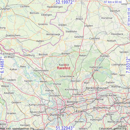
Raesfeld GPS coordinates[2]
51° 46' 0.012" North, 6° 51' 0" East
| Map corner | latitude | longitude |
|---|---|---|
| Upper-left | 52.19972°, | 6.14687° |
| Center: | 51.76667°, | 6.85° |
| Lower-right: | 51.32943°, | 7.55312° |
| Map W x H: | 96.8×96.8 km | = 60.1×60.1mi |
| max Lat: | 55.01917° ⇑30.4% North |
| Raesfeld: | 51.76667° |
| min Lat: | ⇓69.6% South 47.40724° |
| min Long | Raesfeld | max Long |
| 5.92978° | 6.85° | 14.98853° |
| W 4.9%⇐ | ⇒95.1% E |
Elevation
Elevation of Raesfeld is 62 m = 203 ft, and this is 187.1 m = 614 ft below average elevation for this country.
| Max E: |
1256 m = 4121 ft | 75.3% |
| Avg. | 249.1 m = 817 ft | |
| Raesfeld | 62 m = 203 ft | |
Min E: |
-5 m = -16 ft | 24.7% |
See also: Germany elevation on elevation.city.
Geographical zone
Raesfeld is located in North temperate zone (between Tropic of Cancer and the Arctic Circle). Distance of this North polar circle is 1645.3 km =1022.3 mi to North.| Distance of | km | miles | from Raesfeld |
|---|---|---|---|
| North Pole | 4251.1 | 2641.5 | to North |
| Arctic Circle | 1645.3 | 1022.3 | to North |
| Tropic Cancer | 3150 | 1957.3 | to South |
| Equator | 5755.9 | 3576.5 | to South |


Nearby cities:
15 places around Raesfeld: (largest is in red/bold)
• Bocholt
18 km =11.2 mi,  296°
296°
• Borken
8.6 km =5.3 mi,  3°
3°
• Dorsten
14.1 km =8.8 mi,  145°
145°
• Haltern am See
23 km =14.3 mi,  96°
96°
• Hamminkeln
18.3 km =11.4 mi,  258°
258°
• Heiden
9.4 km =5.8 mi,  37°
37°
• Hünxe
18.1 km =11.2 mi,  215°
215°
• Klein Reken
13.5 km =8.4 mi,  80°
80°
• Marl
20.6 km =12.8 mi,  126°
126°
• Rhede
13.1 km =8.1 mi,  305°
305°
• Schermbeck
9.3 km =5.8 mi,  172°
172°
• Südlohn
18.6 km =11.6 mi, 3°
• Velen
17.1 km =10.6 mi,  33°
33°
• Voerde
22 km =13.7 mi,  210°
210°
• Wesel
19.3 km =12 mi,  234°
234°
Sources, notices
• [Note1] Compared only with cities in Germany existing in our database
• [Src1] Map data: © OpenStreetMap contributors (CC-BY-SA)
• [Src2] Other city data from geonames.org with taken over terms of usage.
• [Src3] Geographical zone / Annual Mean Temperature by Robert A. Rohde @ Wikipedia
