Biebesheim geodata
Biebesheim (Hesse) is a populated place; located in Germany in Europe/Berlin (GMT+2) time zone. With population of 6,626 people, there are 2275 cities with bigger population in this country. Compared to other cities in Germany, 69.4% of cities are located further ↑North; 71.4% of cities are located further →East and 69.8% of cities have higher elevation than Biebesheim. Note1
Administrative division(s):
- Level 1: Hesse
- Level 2: Regierungsbezirk Darmstadt
- Level 3: Landkreis Groß-Gerau
- Level 4: Biebesheim am Rhein


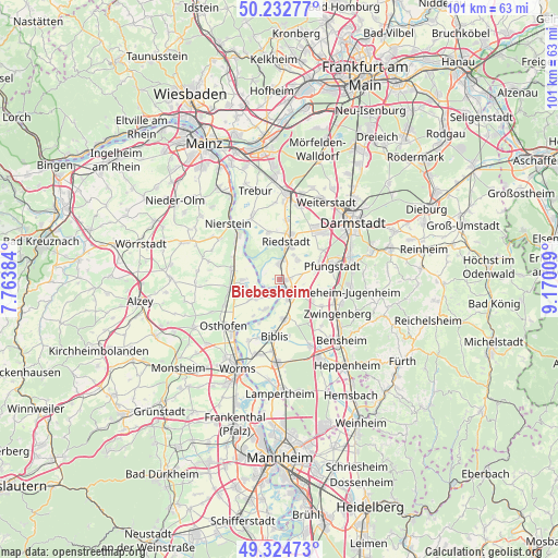
Biebesheim GPS coordinates[2]
49° 46' 51.168" North, 8° 28' 1.056" East
| Map corner | latitude | longitude |
|---|---|---|
| Upper-left | 50.23277°, | 7.76384° |
| Center: | 49.78088°, | 8.46696° |
| Lower-right: | 49.32473°, | 9.17009° |
| Map W x H: | 101×101 km | = 62.8×62.8mi |
| max Lat: | 55.01917° ⇑69.4% North |
| Biebesheim: | 49.78088° |
| min Lat: | ⇓30.6% South 47.40724° |
| min Long | Biebesheim | max Long |
| 5.92978° | 8.46696° | 14.98853° |
| W 28.6%⇐ | ⇒71.4% E |
Elevation
Elevation of Biebesheim is 92 m = 302 ft, and this is 157.1 m = 515 ft below average elevation for this country.
| Max E: |
1256 m = 4121 ft | 69.8% |
| Avg. | 249.1 m = 817 ft | |
| Biebesheim | 92 m = 302 ft | |
Min E: |
-5 m = -16 ft | 30.2% |
See also: Germany elevation on elevation.city.
Geographical zone
Biebesheim is located in North temperate zone (between Tropic of Cancer and the Arctic Circle). Distance of this North polar circle is 1866.1 km =1159.5 mi to North.| Distance of | km | miles | from Biebesheim |
|---|---|---|---|
| North Pole | 4471.9 | 2778.7 | to North |
| Arctic Circle | 1866.1 | 1159.5 | to North |
| Tropic Cancer | 2929.2 | 1820.1 | to South |
| Equator | 5535.1 | 3439.4 | to South |


Nearby cities:
15 places around Biebesheim: (largest is in red/bold)
• Alsbach-Hähnlein
10.4 km =6.5 mi,  116°
116°
• Alsheim
9.2 km =5.7 mi,  261°
261°
• Biblis
9.9 km =6.2 mi,  183°
183°
• Bickenbach
11.1 km =6.9 mi,  102°
102°
• Dienheim
10.5 km =6.5 mi,  306°
306°
• Eich
6 km =3.7 mi,  234°
234°
• Gernsheim
3.5 km =2.2 mi,  153°
153°
• Gimbsheim
6.6 km =4.1 mi,  267°
267°
• Groß-Rohrheim
6.7 km =4.2 mi,  170°
170°
• Guntersblum
8.9 km =5.5 mi,  281°
281°
• Ludwigshöhe
9.7 km =6 mi,  294°
294°
• Mettenheim
11.1 km =6.9 mi,  245°
245°
• Pfungstadt
10.1 km =6.3 mi,  74°
74°
• Riedstadt
6.3 km =3.9 mi,  19°
19°
• Stockstadt am Rhein
3.2 km =2 mi,  7°
7°
Sources, notices
• [Note1] Compared only with cities in Germany existing in our database
• [Src1] Map data: © OpenStreetMap contributors (CC-BY-SA)
• [Src2] Other city data from geonames.org with taken over terms of usage.
• [Src3] Geographical zone / Annual Mean Temperature by Robert A. Rohde @ Wikipedia
