Guntersblum geodata
Guntersblum (Rheinland-Pfalz) is a seat of a fourth-order administrative division; located in Germany in Europe/Berlin (GMT+2) time zone. With population of 3,702 people, there are 3475 cities with bigger population in this country. Compared to other cities in Germany, 69.1% of cities are located further ↑North; 72.4% of cities are located further →East and 69.5% of cities have higher elevation than Guntersblum. Note1
Administrative division(s):
- Level 1: Rheinland-Pfalz
- Level 3: Landkreis Mainz-Bingen
- Level 4: Guntersblum


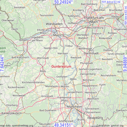
Guntersblum GPS coordinates[2]
49° 47' 51" North, 8° 20' 44.016" East
| Map corner | latitude | longitude |
|---|---|---|
| Upper-left | 50.24924°, | 7.64244° |
| Center: | 49.7975°, | 8.34556° |
| Lower-right: | 49.34151°, | 9.04869° |
| Map W x H: | 100.9×100.9 km | = 62.7×62.7mi |
| max Lat: | 55.01917° ⇑69.1% North |
| Guntersblum: | 49.7975° |
| min Lat: | ⇓30.9% South 47.40724° |
| min Long | Guntersblum | max Long |
| 5.92978° | 8.34556° | 14.98853° |
| W 27.6%⇐ | ⇒72.4% E |
Elevation
Elevation of Guntersblum is 94 m = 308 ft, and this is 155.1 m = 509 ft below average elevation for this country.
| Max E: |
1256 m = 4121 ft | 69.5% |
| Avg. | 249.1 m = 817 ft | |
| Guntersblum | 94 m = 308 ft | |
Min E: |
-5 m = -16 ft | 30.5% |
See also: Germany elevation on elevation.city.
Geographical zone
Guntersblum is located in North temperate zone (between Tropic of Cancer and the Arctic Circle). Distance of this North polar circle is 1864.2 km =1158.4 mi to North.| Distance of | km | miles | from Guntersblum |
|---|---|---|---|
| North Pole | 4470.1 | 2777.6 | to North |
| Arctic Circle | 1864.2 | 1158.4 | to North |
| Tropic Cancer | 2931 | 1821.2 | to South |
| Equator | 5537 | 3440.5 | to South |


Nearby cities:
15 places around Guntersblum: (largest is in red/bold)
• Alsheim
3.3 km =2.1 mi,  186°
186°
• Dalheim
4.9 km =3 mi,  311°
311°
• Dexheim
5.9 km =3.7 mi,  339°
339°
• Dienheim
4.4 km =2.7 mi,  3°
3°
• Dolgesheim
6.4 km =4 mi,  266°
266°
• Dorn-Dürkheim
6.3 km =3.9 mi,  239°
239°
• Eich
6.5 km =4 mi,  144°
144°
• Eimsheim
4 km =2.5 mi, 267°
• Gimbsheim
3 km =1.9 mi, 136°
• Ludwigshöhe
2.1 km =1.3 mi,  356°
356°
• Mettenheim
6.5 km =4 mi, 192°
• Oppenheim
6.4 km =4 mi,  9°
9°
• Uelversheim
4.3 km =2.7 mi,  288°
288°
• Weinolsheim
5.6 km =3.5 mi, 291°
• Wintersheim
5.1 km =3.2 mi,  245°
245°
Sources, notices
• [Note1] Compared only with cities in Germany existing in our database
• [Src1] Map data: © OpenStreetMap contributors (CC-BY-SA)
• [Src2] Other city data from geonames.org with taken over terms of usage.
• [Src3] Geographical zone / Annual Mean Temperature by Robert A. Rohde @ Wikipedia
