Bergwitz geodata
Bergwitz (Saxony-Anhalt) is a populated place; located in Germany in Europe/Berlin (GMT+2) time zone. With population of 1,679 people, there are 5555 cities with bigger population in this country. Compared to other cities in Germany, 69.9% of cities are located further ↓South; 88.7% of cities are located further ←West and 73.6% of cities have higher elevation than Bergwitz. Note1


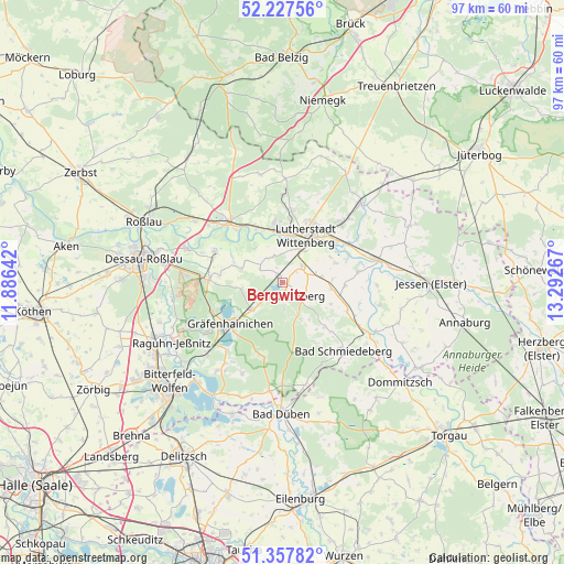
Bergwitz GPS coordinates[2]
51° 47' 41.244" North, 12° 35' 22.344" East
| Map corner | latitude | longitude |
|---|---|---|
| Upper-left | 52.22756°, | 11.88642° |
| Center: | 51.79479°, | 12.58954° |
| Lower-right: | 51.35782°, | 13.29267° |
| Map W x H: | 96.7×96.7 km | = 60.1×60.1mi |
| max Lat: | 55.01917° ⇑30.1% North |
| Bergwitz: | 51.79479° |
| min Lat: | ⇓69.9% South 47.40724° |
| min Long | Bergwitz | max Long |
| 5.92978° | 12.58954° | 14.98853° |
| W 88.7%⇐ | ⇒11.3% E |
Elevation
Elevation of Bergwitz is 69 m = 226 ft, and this is 180.1 m = 591 ft below average elevation for this country.
| Max E: |
1256 m = 4121 ft | 73.6% |
| Avg. | 249.1 m = 817 ft | |
| Bergwitz | 69 m = 226 ft | |
Min E: |
-5 m = -16 ft | 26.4% |
See also: Germany elevation on elevation.city.
Geographical zone
Bergwitz is located in North temperate zone (between Tropic of Cancer and the Arctic Circle). Distance of this North polar circle is 1642.1 km =1020.4 mi to North.| Distance of | km | miles | from Bergwitz |
|---|---|---|---|
| North Pole | 4248 | 2639.6 | to North |
| Arctic Circle | 1642.1 | 1020.4 | to North |
| Tropic Cancer | 3153.1 | 1959.2 | to South |
| Equator | 5759 | 3578.5 | to South |


Nearby cities:
15 places around Bergwitz: (largest is in red/bold)
• Apollensdorf
9.5 km =5.9 mi,  343°
343°
• Ateritz
6.8 km =4.2 mi,  154°
154°
• Dabrun
9.3 km =5.8 mi,  62°
62°
• Elstervorstadt
10.4 km =6.5 mi,  41°
41°
• Eutzsch
4.3 km =2.7 mi,  49°
49°
• Kemberg
3.9 km =2.4 mi,  130°
130°
• Kleinwittenberg
8.1 km =5 mi,  12°
12°
• Piesteritz
8.3 km =5.2 mi,  4°
4°
• Pratau
6.5 km =4 mi, 35°
• Rackith
6.7 km =4.2 mi,  81°
81°
• Radis
7 km =4.3 mi,  227°
227°
• Rothemark
9.8 km =6.1 mi, 11°
• Rotta
3.5 km =2.2 mi,  165°
165°
• Schleesen
7.1 km =4.4 mi,  260°
260°
• Wittenberg
8.9 km =5.5 mi,  27°
27°
Sources, notices
• [Note1] Compared only with cities in Germany existing in our database
• [Src1] Map data: © OpenStreetMap contributors (CC-BY-SA)
• [Src2] Other city data from geonames.org with taken over terms of usage.
• [Src3] Geographical zone / Annual Mean Temperature by Robert A. Rohde @ Wikipedia
