Ateritz geodata
Ateritz (Saxony-Anhalt) is a populated place; located in Germany in Europe/Berlin (GMT+2) time zone. With population of 514 people, there are 9299 cities with bigger population in this country. Compared to other cities in Germany, 69.3% of cities are located further ↓South; 89.2% of cities are located further ←West and 69.2% of cities have higher elevation than Ateritz. Note1


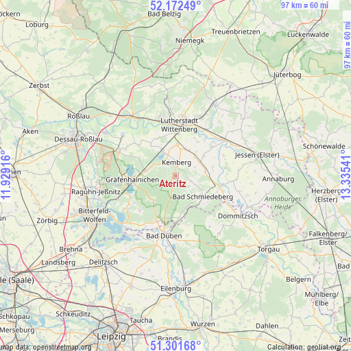
Ateritz GPS coordinates[2]
51° 44' 21.048" North, 12° 37' 56.208" East
| Map corner | latitude | longitude |
|---|---|---|
| Upper-left | 52.17249°, | 11.92916° |
| Center: | 51.73918°, | 12.63228° |
| Lower-right: | 51.30168°, | 13.33541° |
| Map W x H: | 96.8×96.8 km | = 60.1×60.1mi |
| max Lat: | 55.01917° ⇑30.7% North |
| Ateritz: | 51.73918° |
| min Lat: | ⇓69.3% South 47.40724° |
| min Long | Ateritz | max Long |
| 5.92978° | 12.63228° | 14.98853° |
| W 89.2%⇐ | ⇒10.8% E |
Elevation
Elevation of Ateritz is 96 m = 315 ft, and this is 153.1 m = 502 ft below average elevation for this country.
| Max E: |
1256 m = 4121 ft | 69.2% |
| Avg. | 249.1 m = 817 ft | |
| Ateritz | 96 m = 315 ft | |
Min E: |
-5 m = -16 ft | 30.8% |
See also: Germany elevation on elevation.city.
Geographical zone
Ateritz is located in North temperate zone (between Tropic of Cancer and the Arctic Circle). Distance of this North polar circle is 1648.3 km =1024.2 mi to North.| Distance of | km | miles | from Ateritz |
|---|---|---|---|
| North Pole | 4254.2 | 2643.4 | to North |
| Arctic Circle | 1648.3 | 1024.2 | to North |
| Tropic Cancer | 3146.9 | 1955.4 | to South |
| Equator | 5752.9 | 3574.7 | to South |


Nearby cities:
15 places around Ateritz: (largest is in red/bold)
• Bad Schmiedeberg
9.3 km =5.8 mi,  130°
130°
• Bergwitz
6.8 km =4.2 mi,  334°
334°
• Dabrun
11.7 km =7.3 mi,  26°
26°
• Eutzsch
9 km =5.6 mi,  2°
2°
• Gräfenhainichen
12.2 km =7.6 mi,  264°
264°
• Kemberg
3.6 km =2.2 mi,  359°
359°
• Meuro
4.5 km =2.8 mi,  110°
110°
• Pratau
11.5 km =7.1 mi, 3°
• Pretzsch
12.3 km =7.6 mi,  102°
102°
• Rackith
8.1 km =5 mi, 27°
• Radis
8.2 km =5.1 mi,  280°
280°
• Rotta
3.5 km =2.2 mi,  323°
323°
• Schköna
9.2 km =5.7 mi,  225°
225°
• Schleesen
11.2 km =7 mi,  296°
296°
• Söllichau
11.6 km =7.2 mi,  174°
174°
Sources, notices
• [Note1] Compared only with cities in Germany existing in our database
• [Src1] Map data: © OpenStreetMap contributors (CC-BY-SA)
• [Src2] Other city data from geonames.org with taken over terms of usage.
• [Src3] Geographical zone / Annual Mean Temperature by Robert A. Rohde @ Wikipedia
