Köngernheim geodata
Köngernheim (Rheinland-Pfalz) is a seat of a fourth-order administrative division; located in Germany in Europe/Berlin (GMT+2) time zone. With population of 1,398 people, there are 6083 cities with bigger population in this country. Compared to other cities in Germany, 67.8% of cities are located further ↑North; 73.5% of cities are located further →East and 63% of cities have higher elevation than Köngernheim. Note1
Administrative division(s):
- Level 1: Rheinland-Pfalz
- Level 3: Landkreis Mainz-Bingen
- Level 4: Köngernheim


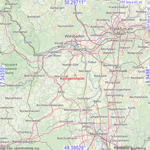
Köngernheim GPS coordinates[2]
49° 50' 44.988" North, 8° 14' 48.012" East
| Map corner | latitude | longitude |
|---|---|---|
| Upper-left | 50.29711°, | 7.54355° |
| Center: | 49.84583°, | 8.24667° |
| Lower-right: | 49.39029°, | 8.9498° |
| Map W x H: | 100.8×100.8 km | = 62.6×62.6mi |
| max Lat: | 55.01917° ⇑67.8% North |
| Köngernheim: | 49.84583° |
| min Lat: | ⇓32.2% South 47.40724° |
| min Long | Köngernheim | max Long |
| 5.92978° | 8.24667° | 14.98853° |
| W 26.5%⇐ | ⇒73.5% E |
Elevation
Elevation of Köngernheim is 132 m = 433 ft, and this is 117.1 m = 384 ft below average elevation for this country.
| Max E: |
1256 m = 4121 ft | 63% |
| Avg. | 249.1 m = 817 ft | |
| Köngernheim | 132 m = 433 ft | |
Min E: |
-5 m = -16 ft | 37% |
See also: Germany elevation on elevation.city.
Geographical zone
Köngernheim is located in North temperate zone (between Tropic of Cancer and the Arctic Circle). Distance of this North polar circle is 1858.8 km =1155 mi to North.| Distance of | km | miles | from Köngernheim |
|---|---|---|---|
| North Pole | 4464.7 | 2774.2 | to North |
| Arctic Circle | 1858.8 | 1155 | to North |
| Tropic Cancer | 2936.4 | 1824.6 | to South |
| Equator | 5542.3 | 3443.8 | to South |


Nearby cities:
15 places around Köngernheim: (largest is in red/bold)
• Dalheim
4.1 km =2.5 mi,  121°
121°
• Dexheim
5 km =3.1 mi,  88°
88°
• Dolgesheim
5.8 km =3.6 mi,  172°
172°
• Friesenheim
1.3 km =0.8 mi,  144°
144°
• Gabsheim
5.4 km =3.4 mi,  248°
248°
• Hahnheim
1.8 km =1.1 mi,  337°
337°
• Mommenheim
4 km =2.5 mi,  18°
18°
• Schornsheim
5.1 km =3.2 mi,  270°
270°
• Selzen
1.8 km =1.1 mi, 20°
• Sörgenloch
5.3 km =3.3 mi,  321°
321°
• Udenheim
5.8 km =3.6 mi,  291°
291°
• Uelversheim
5 km =3.1 mi, 142°
• Undenheim
2.2 km =1.4 mi, 246°
• Weinolsheim
3.8 km =2.4 mi,  150°
150°
• Zornheim
5.2 km =3.2 mi, 342°
Sources, notices
• [Note1] Compared only with cities in Germany existing in our database
• [Src1] Map data: © OpenStreetMap contributors (CC-BY-SA)
• [Src2] Other city data from geonames.org with taken over terms of usage.
• [Src3] Geographical zone / Annual Mean Temperature by Robert A. Rohde @ Wikipedia
