Undenheim geodata
Undenheim (Rheinland-Pfalz) is a seat of a fourth-order administrative division; located in Germany in Europe/Berlin (GMT+2) time zone. With population of 2,525 people, there are 4408 cities with bigger population in this country. Compared to other cities in Germany, 68% of cities are located further ↑North; 73.8% of cities are located further →East and 60.9% of cities have higher elevation than Undenheim. Note1
Administrative division(s):
- Level 1: Rheinland-Pfalz
- Level 3: Landkreis Mainz-Bingen
- Level 4: Undenheim


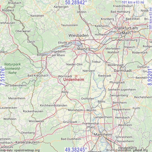
Undenheim GPS coordinates[2]
49° 50' 17.016" North, 8° 13' 8.004" East
| Map corner | latitude | longitude |
|---|---|---|
| Upper-left | 50.28942°, | 7.51576° |
| Center: | 49.83806°, | 8.21889° |
| Lower-right: | 49.38245°, | 8.92201° |
| Map W x H: | 100.8×100.8 km | = 62.6×62.6mi |
| max Lat: | 55.01917° ⇑68% North |
| Undenheim: | 49.83806° |
| min Lat: | ⇓32% South 47.40724° |
| min Long | Undenheim | max Long |
| 5.92978° | 8.21889° | 14.98853° |
| W 26.2%⇐ | ⇒73.8% E |
Elevation
Elevation of Undenheim is 146 m = 479 ft, and this is 103.1 m = 338 ft below average elevation for this country.
| Max E: |
1256 m = 4121 ft | 60.9% |
| Avg. | 249.1 m = 817 ft | |
| Undenheim | 146 m = 479 ft | |
Min E: |
-5 m = -16 ft | 39.1% |
See also: Germany elevation on elevation.city.
Geographical zone
Undenheim is located in North temperate zone (between Tropic of Cancer and the Arctic Circle). Distance of this North polar circle is 1859.7 km =1155.6 mi to North.| Distance of | km | miles | from Undenheim |
|---|---|---|---|
| North Pole | 4465.6 | 2774.8 | to North |
| Arctic Circle | 1859.7 | 1155.6 | to North |
| Tropic Cancer | 2935.6 | 1824.1 | to South |
| Equator | 5541.5 | 3443.3 | to South |


Nearby cities:
15 places around Undenheim: (largest is in red/bold)
• Bechtolsheim
4.2 km =2.6 mi,  205°
205°
• Biebelnheim
5.8 km =3.6 mi,  216°
216°
• Dalheim
5.6 km =3.5 mi,  103°
103°
• Dolgesheim
5.6 km =3.5 mi,  150°
150°
• Friesenheim
2.7 km =1.7 mi,  93°
93°
• Gabsheim
3.3 km =2.1 mi,  249°
249°
• Hahnheim
2.8 km =1.7 mi,  27°
27°
• Köngernheim
2.2 km =1.4 mi,  66°
66°
• Mommenheim
5.7 km =3.5 mi,  35°
35°
• Schornsheim
3.3 km =2.1 mi,  285°
285°
• Selzen
3.6 km =2.2 mi,  46°
46°
• Sörgenloch
5.2 km =3.2 mi,  345°
345°
• Udenheim
4.5 km =2.8 mi,  311°
311°
• Weinolsheim
4.6 km =2.9 mi,  122°
122°
• Zornheim
5.8 km =3.6 mi,  4°
4°
Sources, notices
• [Note1] Compared only with cities in Germany existing in our database
• [Src1] Map data: © OpenStreetMap contributors (CC-BY-SA)
• [Src2] Other city data from geonames.org with taken over terms of usage.
• [Src3] Geographical zone / Annual Mean Temperature by Robert A. Rohde @ Wikipedia
