Hausham geodata
Hausham (Bavaria) is a seat of a fourth-order administrative division; located in Germany in Europe/Berlin (GMT+2) time zone. With population of 8,177 people, there are 1929 cities with bigger population in this country. Compared to other cities in Germany, 98.3% of cities are located further ↑North; 79.4% of cities are located further ←West and 98.9% of cities have lower elevation than Hausham. Note1
Administrative division(s):
- Level 1: Bavaria
- Level 2: Upper Bavaria
- Level 3: Landkreis Miesbach
- Level 4: Hausham


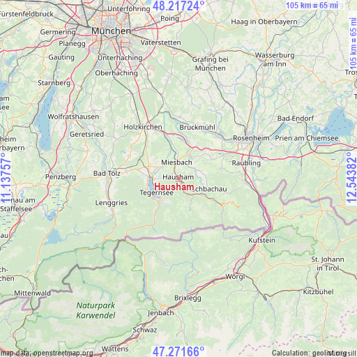
Hausham GPS coordinates[2]
47° 44' 47.76" North, 11° 50' 26.484" East
| Map corner | latitude | longitude |
|---|---|---|
| Upper-left | 48.21724°, | 11.13757° |
| Center: | 47.7466°, | 11.84069° |
| Lower-right: | 47.27166°, | 12.54382° |
| Map W x H: | 105.1×105.1 km | = 65.3×65.3mi |
| max Lat: | 55.01917° ⇑98.3% North |
| Hausham: | 47.7466° |
| min Lat: | ⇓1.7% South 47.40724° |
| min Long | Hausham | max Long |
| 5.92978° | 11.84069° | 14.98853° |
| W 79.4%⇐ | ⇒20.6% E |
Elevation
Elevation of Hausham is 771 m = 2530 ft, and this is 521.9 m = 1712 ft above average elevation for this country.
| Max E: |
1256 m = 4121 ft | 1.1% |
| Hausham | 771 m 2530 ft | |
| Avg. | 249.1 m = 817 ft | |
Min E: |
-5 m = -16 ft | 98.9% |
See also: Germany elevation on elevation.city.
Geographical zone
Hausham is located in North temperate zone (between Tropic of Cancer and the Arctic Circle). Distance of this North polar circle is 2092.2 km =1300 mi to North.| Distance of | km | miles | from Hausham |
|---|---|---|---|
| North Pole | 4698.1 | 2919.3 | to North |
| Arctic Circle | 2092.2 | 1300 | to North |
| Tropic Cancer | 2703 | 1679.6 | to South |
| Equator | 5308.9 | 3298.8 | to South |


Nearby cities:
15 places around Hausham: (largest is in red/bold)
• Bad Feilnbach
13 km =8.1 mi,  76°
76°
• Bad Wiessee
9.9 km =6.2 mi,  250°
250°
• Bayrischzell
15.3 km =9.5 mi,  121°
121°
• Fischbachau
8.8 km =5.5 mi,  110°
110°
• Gmund am Tegernsee
7.7 km =4.8 mi,  273°
273°
• Irschenberg
11.2 km =7 mi,  30°
30°
• Kreuth
13.8 km =8.6 mi,  211°
211°
• Miesbach
4.7 km =2.9 mi,  353°
353°
• Rottach-Egern
8.2 km =5.1 mi,  219°
219°
• Schliersee
1.8 km =1.1 mi,  129°
129°
• Tegernsee
7.3 km =4.5 mi,  238°
238°
• Vagen
14.5 km =9 mi,  12°
12°
• Waakirchen
12.8 km =8 mi,  282°
282°
• Warngau
13 km =8.1 mi,  316°
316°
• Weyarn
12.8 km =8 mi, 346°
Sources, notices
• [Note1] Compared only with cities in Germany existing in our database
• [Src1] Map data: © OpenStreetMap contributors (CC-BY-SA)
• [Src2] Other city data from geonames.org with taken over terms of usage.
• [Src3] Geographical zone / Annual Mean Temperature by Robert A. Rohde @ Wikipedia
