Kreuth geodata
Kreuth (Bavaria) is a seat of a fourth-order administrative division; located in Germany in Europe/Berlin (GMT+2) time zone. In our database, there are 11009 cities with bigger population. Compared to other cities in Germany, 99.3% of cities are located further ↑North; 77.9% of cities are located further ←West and 99% of cities have lower elevation than Kreuth. Note1
Administrative division(s):
- Level 1: Bavaria
- Level 2: Upper Bavaria
- Level 3: Landkreis Miesbach
- Level 4: Kreuth


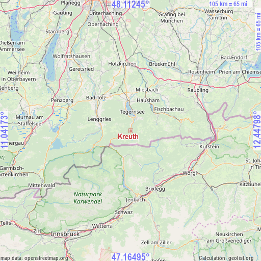
Kreuth GPS coordinates[2]
47° 38' 27.06" North, 11° 44' 41.46" East
| Map corner | latitude | longitude |
|---|---|---|
| Upper-left | 48.11245°, | 11.04173° |
| Center: | 47.64085°, | 11.74485° |
| Lower-right: | 47.16495°, | 12.44798° |
| Map W x H: | 105.4×105.4 km | = 65.5×65.5mi |
| max Lat: | 55.01917° ⇑99.3% North |
| Kreuth: | 47.64085° |
| min Lat: | ⇓0.7% South 47.40724° |
| min Long | Kreuth | max Long |
| 5.92978° | 11.74485° | 14.98853° |
| W 77.9%⇐ | ⇒22.1% E |
Elevation
Elevation of Kreuth is 781 m = 2562 ft, and this is 531.9 m = 1745 ft above average elevation for this country.
| Max E: |
1256 m = 4121 ft | 1% |
| Kreuth | 781 m 2562 ft | |
| Avg. | 249.1 m = 817 ft | |
Min E: |
-5 m = -16 ft | 99% |
See also: Germany elevation on elevation.city.
Geographical zone
Kreuth is located in North temperate zone (between Tropic of Cancer and the Arctic Circle). Distance of this North polar circle is 2104 km =1307.4 mi to North.| Distance of | km | miles | from Kreuth |
|---|---|---|---|
| North Pole | 4709.9 | 2926.6 | to North |
| Arctic Circle | 2104 | 1307.4 | to North |
| Tropic Cancer | 2691.2 | 1672.2 | to South |
| Equator | 5297.2 | 3291.5 | to South |


Nearby cities:
15 places around Kreuth: (largest is in red/bold)
• Bad Tölz
19.3 km =12 mi,  313°
313°
• Bad Wiessee
8.7 km =5.4 mi,  345°
345°
• Fischbachau
17.7 km =11 mi,  60°
60°
• Gaißach
17.1 km =10.6 mi,  315°
315°
• Gmund am Tegernsee
12.3 km =7.6 mi,  357°
357°
• Greiling
17 km =10.6 mi,  325°
325°
• Hausham
13.8 km =8.6 mi,  31°
31°
• Lenggries
14.2 km =8.8 mi,  289°
289°
• Miesbach
17.8 km =11.1 mi,  21°
21°
• Reichersbeuern
16.3 km =10.1 mi, 329°
• Rottach-Egern
5.8 km =3.6 mi, 19°
• Schliersee
13.6 km =8.5 mi,  38°
38°
• Tegernsee
8 km =5 mi,  7°
7°
• Waakirchen
15.6 km =9.7 mi,  339°
339°
• Wackersberg
17.8 km =11.1 mi, 305°
Sources, notices
• [Note1] Compared only with cities in Germany existing in our database
• [Src1] Map data: © OpenStreetMap contributors (CC-BY-SA)
• [Src2] Other city data from geonames.org with taken over terms of usage.
• [Src3] Geographical zone / Annual Mean Temperature by Robert A. Rohde @ Wikipedia
