Bad Neuenahr-Ahrweiler geodata
Bad Neuenahr-Ahrweiler (Rheinland-Pfalz) is a seat of a third-order administrative division; located in Germany in Europe/Berlin (GMT+2) time zone. With population of 27,823 people, there are 511 cities with bigger population in this country. Compared to other cities in Germany, 51.9% of cities are located further ↑North; 92.3% of cities are located further →East and 68.3% of cities have higher elevation than Bad Neuenahr-Ahrweiler. Note1
Administrative division(s):
- Level 1: Rheinland-Pfalz
- Level 3: Landkreis Ahrweiler
- Level 4: Bad Neuenahr-Ahrweiler
Current local time in Bad Neuenahr-Ahrweiler:
03:55 PM, TuesdayDifference from your time zone: hours


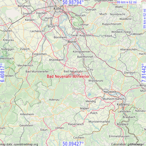
Bad Neuenahr-Ahrweiler GPS coordinates[2]
50° 32' 35.592" North, 7° 6' 40.68" East
| Map corner | latitude | longitude |
|---|---|---|
| Upper-left | 50.98794°, | 6.40817° |
| Center: | 50.54322°, | 7.1113° |
| Lower-right: | 50.09427°, | 7.81442° |
| Map W x H: | 99.4×99.4 km | = 61.8×61.8mi |
| max Lat: | 55.01917° ⇑51.9% North |
| Bad Neuenahr-Ahrweiler: | 50.54322° |
| min Lat: | ⇓48.1% South 47.40724° |
| min Long | Bad Neuenahr-Ah | max Long |
| 5.92978° | 7.1113° | 14.98853° |
| W 7.7%⇐ | ⇒92.3% E |
Elevation
Elevation of Bad Neuenahr-Ahrweiler is 101 m = 331 ft, and this is 148.1 m = 486 ft below average elevation for this country.
| Max E: |
1256 m = 4121 ft | 68.3% |
| Avg. | 249.1 m = 817 ft | |
| Bad Neuenahr-Ahrweiler | 101 m = 331 ft | |
Min E: |
-5 m = -16 ft | 31.7% |
See also: Germany elevation on elevation.city.
Geographical zone
Bad Neuenahr-Ahrweiler is located in North temperate zone (between Tropic of Cancer and the Arctic Circle). Distance of this North polar circle is 1781.3 km =1106.8 mi to North.| Distance of | km | miles | from Bad Neuenahr-Ahrweiler |
|---|---|---|---|
| North Pole | 4387.2 | 2726.1 | to North |
| Arctic Circle | 1781.3 | 1106.8 | to North |
| Tropic Cancer | 3014 | 1872.8 | to South |
| Equator | 5619.9 | 3492 | to South |


Nearby cities:
15 places around Bad Neuenahr-Ahrweiler: (largest is in red/bold)
• Altenahr
8.9 km =5.5 mi,  250°
250°
• Dedenbach
8.4 km =5.2 mi,  142°
142°
• Dernau
4.5 km =2.8 mi,  255°
255°
• Erpel
9.7 km =6 mi,  62°
62°
• Heckenbach
9.6 km =6 mi,  206°
206°
• Kalenborn
7.9 km =4.9 mi,  275°
275°
• Kesseling
9.4 km =5.8 mi,  225°
225°
• Königsfeld
6.9 km =4.3 mi, 137°
• Mayschoß
7.1 km =4.4 mi, 249°
• Oberdürenbach
9.4 km =5.8 mi,  155°
155°
• Rech
6.3 km =3.9 mi,  241°
241°
• Remagen
9.1 km =5.7 mi, 64°
• Schalkenbach
5.9 km =3.7 mi, 155°
• Sinzig
9.5 km =5.9 mi,  89°
89°
• Unkel
9.6 km =6 mi,  52°
52°
Sources, notices
• [Note1] Compared only with cities in Germany existing in our database
• [Src1] Map data: © OpenStreetMap contributors (CC-BY-SA)
• [Src2] Other city data from geonames.org with taken over terms of usage.
• [Src3] Geographical zone / Annual Mean Temperature by Robert A. Rohde @ Wikipedia
