Stockelsdorf geodata
Stockelsdorf (Schleswig-Holstein) is a seat of a fourth-order administrative division; located in Germany in Europe/Berlin (GMT+2) time zone. With population of 16,562 people, there are 957 cities with bigger population in this country. Compared to other cities in Germany, 91.1% of cities are located further ↓South; 61.6% of cities are located further ←West and 87.7% of cities have higher elevation than Stockelsdorf. Note1
Administrative division(s):
- Level 1: Schleswig-Holstein
- Level 3: Kreis Ostholstein
- Level 4: Stockelsdorf


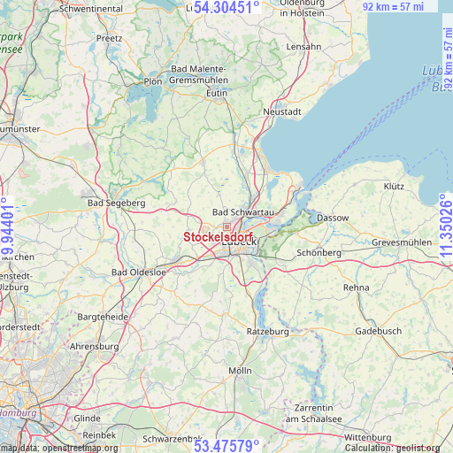
Stockelsdorf GPS coordinates[2]
53° 53' 31.92" North, 10° 38' 49.668" East
| Map corner | latitude | longitude |
|---|---|---|
| Upper-left | 54.30451°, | 9.94401° |
| Center: | 53.8922°, | 10.64713° |
| Lower-right: | 53.47579°, | 11.35026° |
| Map W x H: | 92.1×92.1 km | = 57.2×57.2mi |
| max Lat: | 55.01917° ⇑8.9% North |
| Stockelsdorf: | 53.8922° |
| min Lat: | ⇓91.1% South 47.40724° |
| min Long | Stockelsdorf | max Long |
| 5.92978° | 10.64713° | 14.98853° |
| W 61.6%⇐ | ⇒38.4% E |
Elevation
Elevation of Stockelsdorf is 28 m = 92 ft, and this is 221.1 m = 725 ft below average elevation for this country.
| Max E: |
1256 m = 4121 ft | 87.7% |
| Avg. | 249.1 m = 817 ft | |
| Stockelsdorf | 28 m = 92 ft | |
Min E: |
-5 m = -16 ft | 12.3% |
See also: Germany elevation on elevation.city.
Geographical zone
Stockelsdorf is located in North temperate zone (between Tropic of Cancer and the Arctic Circle). Distance of this North polar circle is 1408.9 km =875.4 mi to North.| Distance of | km | miles | from Stockelsdorf |
|---|---|---|---|
| North Pole | 4014.8 | 2494.7 | to North |
| Arctic Circle | 1408.9 | 875.4 | to North |
| Tropic Cancer | 3386.3 | 2104.1 | to South |
| Equator | 5992.3 | 3723.4 | to South |


Nearby cities:
15 places around Stockelsdorf: (largest is in red/bold)
• Bad Schwartau
4.4 km =2.7 mi,  47°
47°
• Badendorf
6 km =3.7 mi,  241°
241°
• Groß Schenkenberg
11.5 km =7.1 mi,  207°
207°
• Hamberge
7.8 km =4.8 mi, 212°
• Heidekamp
10.7 km =6.6 mi, 244°
• Heilshoop
7.5 km =4.7 mi,  262°
262°
• Klein Wesenberg
10.5 km =6.5 mi,  217°
217°
• Krummesse
12.1 km =7.5 mi,  179°
179°
• Lübeck
3.7 km =2.3 mi,  134°
134°
• Mönkhagen
6.4 km =4 mi,  277°
277°
• Ratekau
8.6 km =5.3 mi,  41°
41°
• Rehhorst
11.9 km =7.4 mi,  265°
265°
• Strukdorf
11.1 km =6.9 mi, 284°
• Wesenberg
9.1 km =5.7 mi, 224°
• Zarpen
9 km =5.6 mi,  251°
251°
Sources, notices
• [Note1] Compared only with cities in Germany existing in our database
• [Src1] Map data: © OpenStreetMap contributors (CC-BY-SA)
• [Src2] Other city data from geonames.org with taken over terms of usage.
• [Src3] Geographical zone / Annual Mean Temperature by Robert A. Rohde @ Wikipedia
