Lübeck geodata
Lübeck (Schleswig-Holstein) is a seat of a third-order administrative division; located in Germany in Europe/Berlin (GMT+2) time zone. With population of 212,207 people, there are 43 cities with bigger population in this country. Compared to other cities in Germany, 90.8% of cities are located further ↓South; 62.3% of cities are located further ←West and 92% of cities have higher elevation than Lübeck. Note1
Administrative division(s):
- Level 1: Schleswig-Holstein
- Level 3: Kreisfreie Stadt Lübeck
- Level 4: Lübeck, Hansestadt


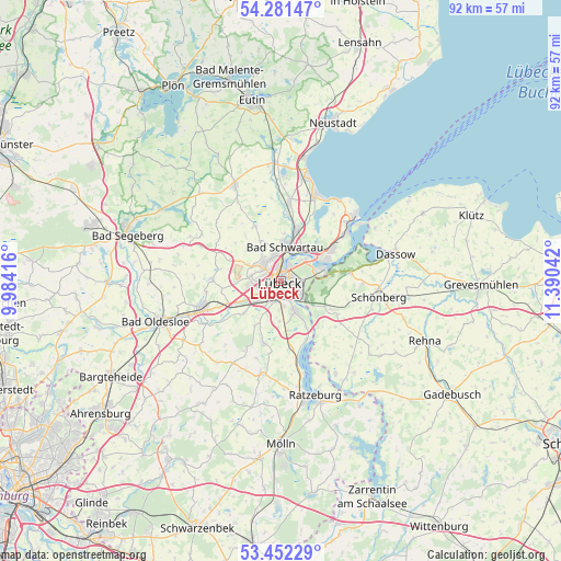
Lübeck GPS coordinates[2]
53° 52' 8.148" North, 10° 41' 14.244" East
| Map corner | latitude | longitude |
|---|---|---|
| Upper-left | 54.28147°, | 9.98416° |
| Center: | 53.86893°, | 10.68729° |
| Lower-right: | 53.45229°, | 11.39042° |
| Map W x H: | 92.2×92.2 km | = 57.3×57.3mi |
| max Lat: | 55.01917° ⇑9.2% North |
| Lübeck: | 53.86893° |
| min Lat: | ⇓90.8% South 47.40724° |
| min Long | Lübeck | max Long |
| 5.92978° | 10.68729° | 14.98853° |
| W 62.3%⇐ | ⇒37.7% E |
Elevation
Elevation of Lübeck is 16 m = 52 ft, and this is 233.1 m = 765 ft below average elevation for this country.
| Max E: |
1256 m = 4121 ft | 92% |
| Avg. | 249.1 m = 817 ft | |
| Lübeck | 16 m = 52 ft | |
Min E: |
-5 m = -16 ft | 8% |
See also: Lübeck elevation on elevation.city.
Geographical zone
Lübeck is located in North temperate zone (between Tropic of Cancer and the Arctic Circle). Distance of this North polar circle is 1411.5 km =877.1 mi to North.| Distance of | km | miles | from Lübeck |
|---|---|---|---|
| North Pole | 4017.4 | 2496.3 | to North |
| Arctic Circle | 1411.5 | 877.1 | to North |
| Tropic Cancer | 3383.7 | 2102.5 | to South |
| Equator | 5989.7 | 3721.8 | to South |


Nearby cities:
15 places around Lübeck: (largest is in red/bold)
• Bad Schwartau
5.6 km =3.5 mi,  6°
6°
• Badendorf
7.9 km =4.9 mi,  268°
268°
• Groß Grönau
8.7 km =5.4 mi,  151°
151°
• Groß Schenkenberg
11 km =6.8 mi,  225°
225°
• Hamberge
7.9 km =4.9 mi,  239°
239°
• Heilshoop
10.2 km =6.3 mi,  279°
279°
• Klein Wesenberg
10.7 km =6.6 mi, 237°
• Klempau
11.5 km =7.1 mi,  186°
186°
• Krummesse
9.8 km =6.1 mi, 194°
• Mönkhagen
9.6 km =6 mi,  291°
291°
• Ratekau
9.5 km =5.9 mi,  18°
18°
• Selmsdorf
11.4 km =7.1 mi,  82°
82°
• Stockelsdorf
3.7 km =2.3 mi,  314°
314°
• Wesenberg
9.8 km =6.1 mi,  246°
246°
• Zarpen
11.2 km =7 mi, 268°
Sources, notices
• [Note1] Compared only with cities in Germany existing in our database
• [Src1] Map data: © OpenStreetMap contributors (CC-BY-SA)
• [Src2] Other city data from geonames.org with taken over terms of usage.
• [Src3] Geographical zone / Annual Mean Temperature by Robert A. Rohde @ Wikipedia
