Münster geodata
Münster (North Rhine-Westphalia) is a seat of a second-order administrative division; located in Germany in Europe/Berlin (GMT+2) time zone. With population of 270,184 people, there are 26 cities with bigger population in this country. Compared to other cities in Germany, 71.8% of cities are located further ↓South; 84.5% of cities are located further →East and 74.7% of cities have higher elevation than Münster. Note1
Administrative division(s):
- Level 1: North Rhine-Westphalia
- Level 2: Regierungsbezirk Münster
- Level 3: Kreisfreie Stadt Münster
- Level 4: Münster


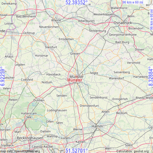
Münster GPS coordinates[2]
51° 57' 44.496" North, 7° 37' 32.556" East
| Map corner | latitude | longitude |
|---|---|---|
| Upper-left | 52.39352°, | 6.92259° |
| Center: | 51.96236°, | 7.62571° |
| Lower-right: | 51.52701°, | 8.32884° |
| Map W x H: | 96.3×96.3 km | = 59.8×59.8mi |
| max Lat: | 55.01917° ⇑28.2% North |
| Münster: | 51.96236° |
| min Lat: | ⇓71.8% South 47.40724° |
| min Long | Münster | max Long |
| 5.92978° | 7.62571° | 14.98853° |
| W 15.5%⇐ | ⇒84.5% E |
Elevation
Elevation of Münster is 64 m = 210 ft, and this is 185.1 m = 607 ft below average elevation for this country.
| Max E: |
1256 m = 4121 ft | 74.7% |
| Avg. | 249.1 m = 817 ft | |
| Münster | 64 m = 210 ft | |
Min E: |
-5 m = -16 ft | 25.3% |
See also: Münster elevation on elevation.city.
Geographical zone
Münster is located in North temperate zone (between Tropic of Cancer and the Arctic Circle). Distance of this North polar circle is 1623.5 km =1008.8 mi to North.| Distance of | km | miles | from Münster |
|---|---|---|---|
| North Pole | 4229.4 | 2628 | to North |
| Arctic Circle | 1623.5 | 1008.8 | to North |
| Tropic Cancer | 3171.8 | 1970.9 | to South |
| Equator | 5777.7 | 3590.1 | to South |


Nearby cities:
15 places around Münster: (largest is in red/bold)
• Altenberge
14.6 km =9.1 mi,  311°
311°
• Ascheberg
19.9 km =12.4 mi,  181°
181°
• Billerbeck
22.9 km =14.2 mi,  274°
274°
• Drensteinfurt
20.1 km =12.5 mi,  157°
157°
• Everswinkel
15.7 km =9.8 mi,  104°
104°
• Greven
14.8 km =9.2 mi,  351°
351°
• Havixbeck
14.5 km =9 mi,  279°
279°
• Ladbergen
20.8 km =12.9 mi,  24°
24°
• Laer
21.1 km =13.1 mi,  299°
299°
• Nordwalde
16.6 km =10.3 mi,  324°
324°
• Nottuln
19.2 km =11.9 mi,  260°
260°
• Ostbevern
17.2 km =10.7 mi,  59°
59°
• Senden
15.3 km =9.5 mi,  219°
219°
• Sendenhorst
19.3 km =12 mi,  133°
133°
• Telgte
10.9 km =6.8 mi,  79°
79°
In other languages:
- In German: Münster, Münster / Nordrhein-Westf.
- In Russian: Мюнстер
- In Chinese: 明斯特
Sources, notices
• [Note1] Compared only with cities in Germany existing in our database
• [Src1] Map data: © OpenStreetMap contributors (CC-BY-SA)
• [Src2] Other city data from geonames.org with taken over terms of usage.
• [Src3] Geographical zone / Annual Mean Temperature by Robert A. Rohde @ Wikipedia
