Sendenhorst geodata
Sendenhorst (North Rhine-Westphalia) is a populated place; located in Germany in Europe/Berlin (GMT+2) time zone. With population of 13,316 people, there are 1200 cities with bigger population in this country. Compared to other cities in Germany, 70.4% of cities are located further ↓South; 80.4% of cities are located further →East and 73.6% of cities have higher elevation than Sendenhorst. Note1
Administrative division(s):
- Level 1: North Rhine-Westphalia
- Level 2: Regierungsbezirk Münster
- Level 3: Kreis Warendorf
- Level 4: Sendenhorst


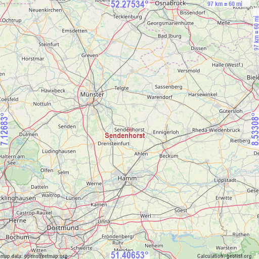
Sendenhorst GPS coordinates[2]
51° 50' 34.908" North, 7° 49' 47.856" East
| Map corner | latitude | longitude |
|---|---|---|
| Upper-left | 52.27534°, | 7.12683° |
| Center: | 51.84303°, | 7.82996° |
| Lower-right: | 51.40653°, | 8.53308° |
| Map W x H: | 96.6×96.6 km | = 60×60mi |
| max Lat: | 55.01917° ⇑29.6% North |
| Sendenhorst: | 51.84303° |
| min Lat: | ⇓70.4% South 47.40724° |
| min Long | Sendenhorst | max Long |
| 5.92978° | 7.82996° | 14.98853° |
| W 19.6%⇐ | ⇒80.4% E |
Elevation
Elevation of Sendenhorst is 69 m = 226 ft, and this is 180.1 m = 591 ft below average elevation for this country.
| Max E: |
1256 m = 4121 ft | 73.6% |
| Avg. | 249.1 m = 817 ft | |
| Sendenhorst | 69 m = 226 ft | |
Min E: |
-5 m = -16 ft | 26.4% |
See also: Germany elevation on elevation.city.
Geographical zone
Sendenhorst is located in North temperate zone (between Tropic of Cancer and the Arctic Circle). Distance of this North polar circle is 1636.8 km =1017.1 mi to North.| Distance of | km | miles | from Sendenhorst |
|---|---|---|---|
| North Pole | 4242.7 | 2636.3 | to North |
| Arctic Circle | 1636.8 | 1017.1 | to North |
| Tropic Cancer | 3158.5 | 1962.6 | to South |
| Equator | 5764.4 | 3581.8 | to South |


Nearby cities:
15 places around Sendenhorst: (largest is in red/bold)
• Ahlen
9.7 km =6 mi,  155°
155°
• Ascheberg
16.1 km =10 mi,  245°
245°
• Beckum
17.4 km =10.8 mi,  123°
123°
• Beelen
21.5 km =13.4 mi,  63°
63°
• Drensteinfurt
8.2 km =5.1 mi,  229°
229°
• Ennigerloh
13.8 km =8.6 mi,  92°
92°
• Everswinkel
9.3 km =5.8 mi,  7°
7°
• Hamm
18.1 km =11.2 mi,  181°
181°
• Münster
19.3 km =12 mi,  313°
313°
• Oelde
21.9 km =13.6 mi, 94°
• Ostbevern
21.9 km =13.6 mi,  2°
2°
• Sassenberg
22 km =13.7 mi,  41°
41°
• Senden
23.9 km =14.9 mi,  273°
273°
• Telgte
15.6 km =9.7 mi,  348°
348°
• Warendorf
16.2 km =10.1 mi, 41°
Sources, notices
• [Note1] Compared only with cities in Germany existing in our database
• [Src1] Map data: © OpenStreetMap contributors (CC-BY-SA)
• [Src2] Other city data from geonames.org with taken over terms of usage.
• [Src3] Geographical zone / Annual Mean Temperature by Robert A. Rohde @ Wikipedia
