Artern geodata
Artern (Thuringia) is a populated place; located in Germany in Europe/Berlin (GMT+2) time zone. With population of 6,270 people, there are 2376 cities with bigger population in this country. Compared to other cities in Germany, 64.2% of cities are located further ↓South; 71.2% of cities are located further ←West and 63.9% of cities have higher elevation than Artern. Note1


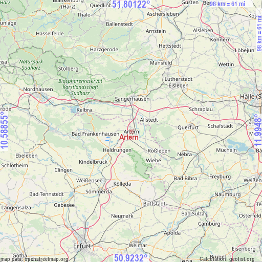
Artern GPS coordinates[2]
51° 21' 51.516" North, 11° 17' 30.012" East
| Map corner | latitude | longitude |
|---|---|---|
| Upper-left | 51.80122°, | 10.58855° |
| Center: | 51.36431°, | 11.29167° |
| Lower-right: | 50.9232°, | 11.9948° |
| Map W x H: | 97.6×97.6 km | = 60.6×60.6mi |
| max Lat: | 55.01917° ⇑35.8% North |
| Artern: | 51.36431° |
| min Lat: | ⇓64.2% South 47.40724° |
| min Long | Artern | max Long |
| 5.92978° | 11.29167° | 14.98853° |
| W 71.2%⇐ | ⇒28.8% E |
Elevation
Elevation of Artern is 127 m = 417 ft, and this is 122.1 m = 401 ft below average elevation for this country.
| Max E: |
1256 m = 4121 ft | 63.9% |
| Avg. | 249.1 m = 817 ft | |
| Artern | 127 m = 417 ft | |
Min E: |
-5 m = -16 ft | 36.1% |
See also: Germany elevation on elevation.city.
Geographical zone
Artern is located in North temperate zone (between Tropic of Cancer and the Arctic Circle). Distance of this North polar circle is 1690 km =1050.1 mi to North.| Distance of | km | miles | from Artern |
|---|---|---|---|
| North Pole | 4295.9 | 2669.3 | to North |
| Arctic Circle | 1690 | 1050.1 | to North |
| Tropic Cancer | 3105.3 | 1929.5 | to South |
| Equator | 5711.2 | 3548.8 | to South |


Nearby cities:
15 places around Artern: (largest is in red/bold)
• Allstedt
7.9 km =4.9 mi,  56°
56°
• Borxleben
5.7 km =3.5 mi,  314°
314°
• Bretleben
5.3 km =3.3 mi,  229°
229°
• Edersleben
5.9 km =3.7 mi,  354°
354°
• Gehofen
5 km =3.1 mi,  156°
156°
• Heygendorf
5.1 km =3.2 mi,  106°
106°
• Ichstedt
6.7 km =4.2 mi,  288°
288°
• Kalbsrieth
4.2 km =2.6 mi,  126°
126°
• Mönchpfiffel-Nikolausrieth
5.6 km =3.5 mi,  67°
67°
• Nausitz
6 km =3.7 mi,  151°
151°
• Reinsdorf
3.9 km =2.4 mi,  206°
206°
• Riethnordhausen
7.4 km =4.6 mi,  328°
328°
• Ringleben
5.2 km =3.2 mi,  272°
272°
• Schönewerda
6.9 km =4.3 mi, 131°
• Voigtstedt
3.3 km =2.1 mi,  21°
21°
In other languages:
- In German: Artern/Unstrut
- In Italian: Artern/Unstrut
- In Russian: Артерн
- In Chinese: 阿尔特尔恩
Sources, notices
• [Note1] Compared only with cities in Germany existing in our database
• [Src1] Map data: © OpenStreetMap contributors (CC-BY-SA)
• [Src2] Other city data from geonames.org with taken over terms of usage.
• [Src3] Geographical zone / Annual Mean Temperature by Robert A. Rohde @ Wikipedia
