Arnsberg geodata
Arnsberg (North Rhine-Westphalia) is a seat of a second-order administrative division; located in Germany in Europe/Berlin (GMT+2) time zone. With population of 76,612 people, there are 133 cities with bigger population in this country. Compared to other cities in Germany, 64.4% of cities are located further ↓South; 75.7% of cities are located further →East and 60.9% of cities have lower elevation than Arnsberg. Note1
Administrative division(s):
- Level 1: North Rhine-Westphalia
- Level 2: Regierungsbezirk Arnsberg
- Level 3: Hochsauerlandkreis
- Level 4: Arnsberg


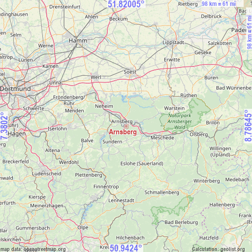
Arnsberg GPS coordinates[2]
51° 22' 59.988" North, 8° 4' 59.988" East
| Map corner | latitude | longitude |
|---|---|---|
| Upper-left | 51.82005°, | 7.3802° |
| Center: | 51.38333°, | 8.08333° |
| Lower-right: | 50.9424°, | 8.78645° |
| Map W x H: | 97.6×97.6 km | = 60.6×60.6mi |
| max Lat: | 55.01917° ⇑35.6% North |
| Arnsberg: | 51.38333° |
| min Lat: | ⇓64.4% South 47.40724° |
| min Long | Arnsberg | max Long |
| 5.92978° | 8.08333° | 14.98853° |
| W 24.3%⇐ | ⇒75.7% E |
Elevation
Elevation of Arnsberg is 295 m = 968 ft, and this is 45.9 m = 151 ft above average elevation for this country.
| Max E: |
1256 m = 4121 ft | 39.1% |
| Arnsberg | 295 m 968 ft | |
| Avg. | 249.1 m = 817 ft | |
Min E: |
-5 m = -16 ft | 60.9% |
See also: Arnsberg elevation on elevation.city.
Geographical zone
Arnsberg is located in North temperate zone (between Tropic of Cancer and the Arctic Circle). Distance of this North polar circle is 1687.9 km =1048.8 mi to North.| Distance of | km | miles | from Arnsberg |
|---|---|---|---|
| North Pole | 4293.8 | 2668 | to North |
| Arctic Circle | 1687.9 | 1048.8 | to North |
| Tropic Cancer | 3107.4 | 1930.8 | to South |
| Equator | 5713.3 | 3550.1 | to South |


Nearby cities:
15 places around Arnsberg: (largest is in red/bold)
• Bad Sassendorf
23 km =14.3 mi,  14°
14°
• Balve
16.3 km =10.1 mi,  249°
249°
• Bestwig
22.2 km =13.8 mi,  96°
96°
• Eslohe
15.6 km =9.7 mi,  157°
157°
• Fröndenberg
24.1 km =15 mi,  295°
295°
• Hemer
21.7 km =13.5 mi,  271°
271°
• Menden
22.2 km =13.8 mi,  287°
287°
• Meschede
14.4 km =8.9 mi, 104°
• Möhnesee
13.4 km =8.3 mi, 14°
• Neuenrade
23.7 km =14.7 mi,  241°
241°
• Soest
21.4 km =13.3 mi,  4°
4°
• Sundern
8.3 km =5.2 mi,  222°
222°
• Warstein
19.6 km =12.2 mi,  69°
69°
• Werl
22.4 km =13.9 mi,  328°
328°
• Wickede
19.6 km =12.2 mi,  309°
309°
Sources, notices
• [Note1] Compared only with cities in Germany existing in our database
• [Src1] Map data: © OpenStreetMap contributors (CC-BY-SA)
• [Src2] Other city data from geonames.org with taken over terms of usage.
• [Src3] Geographical zone / Annual Mean Temperature by Robert A. Rohde @ Wikipedia
