Sundern geodata
Sundern (North Rhine-Westphalia) is a populated place; located in Germany in Europe/Berlin (GMT+2) time zone. With population of 29,609 people, there are 473 cities with bigger population in this country. Compared to other cities in Germany, 63.7% of cities are located further ↓South; 77% of cities are located further →East and 54.9% of cities have lower elevation than Sundern. Note1
Administrative division(s):
- Level 1: North Rhine-Westphalia
- Level 2: Regierungsbezirk Arnsberg
- Level 3: Hochsauerlandkreis
- Level 4: Sundern (Sauerland)


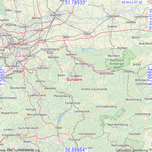
Sundern GPS coordinates[2]
51° 19' 41.16" North, 8° 0' 13.284" East
| Map corner | latitude | longitude |
|---|---|---|
| Upper-left | 51.76535°, | 7.30057° |
| Center: | 51.3281°, | 8.00369° |
| Lower-right: | 50.88664°, | 8.70682° |
| Map W x H: | 97.7×97.7 km | = 60.7×60.7mi |
| max Lat: | 55.01917° ⇑36.3% North |
| Sundern: | 51.3281° |
| min Lat: | ⇓63.7% South 47.40724° |
| min Long | Sundern | max Long |
| 5.92978° | 8.00369° | 14.98853° |
| W 23%⇐ | ⇒77% E |
Elevation
Elevation of Sundern is 257 m = 843 ft, and this is 7.9 m = 26 ft above average elevation for this country.
| Max E: |
1256 m = 4121 ft | 45.1% |
| Sundern | 257 m 843 ft | |
| Avg. | 249.1 m = 817 ft | |
Min E: |
-5 m = -16 ft | 54.9% |
See also: Germany elevation on elevation.city.
Geographical zone
Sundern is located in North temperate zone (between Tropic of Cancer and the Arctic Circle). Distance of this North polar circle is 1694 km =1052.6 mi to North.| Distance of | km | miles | from Sundern |
|---|---|---|---|
| North Pole | 4299.9 | 2671.8 | to North |
| Arctic Circle | 1694 | 1052.6 | to North |
| Tropic Cancer | 3101.2 | 1927 | to South |
| Equator | 5707.1 | 3546.2 | to South |


Nearby cities:
15 places around Sundern: (largest is in red/bold)
• Arnsberg
8.3 km =5.2 mi,  42°
42°
• Balve
9.7 km =6 mi,  272°
272°
• Bamenohl
18.2 km =11.3 mi,  184°
184°
• Eslohe
14.2 km =8.8 mi,  125°
125°
• Finnentrop
17.9 km =11.1 mi,  186°
186°
• Fröndenberg
23.1 km =14.4 mi,  315°
315°
• Hemer
17.5 km =10.9 mi,  292°
292°
• Iserlohn
21.5 km =13.4 mi,  284°
284°
• Menden
20.2 km =12.6 mi,  309°
309°
• Meschede
19.6 km =12.2 mi,  82°
82°
• Möhnesee
21.1 km =13.1 mi,  25°
25°
• Neuenrade
16.2 km =10.1 mi,  251°
251°
• Plettenberg
16 km =9.9 mi,  214°
214°
• Werdohl
18.2 km =11.3 mi, 245°
• Wickede
21 km =13 mi,  332°
332°
Sources, notices
• [Note1] Compared only with cities in Germany existing in our database
• [Src1] Map data: © OpenStreetMap contributors (CC-BY-SA)
• [Src2] Other city data from geonames.org with taken over terms of usage.
• [Src3] Geographical zone / Annual Mean Temperature by Robert A. Rohde @ Wikipedia
