Apensen geodata
Apensen (Lower Saxony) is a seat of a fourth-order administrative division; located in Germany in Europe/Berlin (GMT+2) time zone. With population of 2,987 people, there are 4013 cities with bigger population in this country. Compared to other cities in Germany, 84.8% of cities are located further ↓South; 55.9% of cities are located further →East and 81.4% of cities have higher elevation than Apensen. Note1


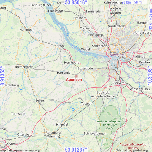
Apensen GPS coordinates[2]
53° 25' 59.988" North, 9° 37' 0.012" East
| Map corner | latitude | longitude |
|---|---|---|
| Upper-left | 53.85016°, | 8.91355° |
| Center: | 53.43333°, | 9.61667° |
| Lower-right: | 53.01237°, | 10.3198° |
| Map W x H: | 93.2×93.2 km | = 57.9×57.9mi |
| max Lat: | 55.01917° ⇑15.2% North |
| Apensen: | 53.43333° |
| min Lat: | ⇓84.8% South 47.40724° |
| min Long | Apensen | max Long |
| 5.92978° | 9.61667° | 14.98853° |
| W 44.1%⇐ | ⇒55.9% E |
Elevation
Elevation of Apensen is 43 m = 141 ft, and this is 206.1 m = 676 ft below average elevation for this country.
| Max E: |
1256 m = 4121 ft | 81.4% |
| Avg. | 249.1 m = 817 ft | |
| Apensen | 43 m = 141 ft | |
Min E: |
-5 m = -16 ft | 18.6% |
See also: Germany elevation on elevation.city.
Geographical zone
Apensen is located in North temperate zone (between Tropic of Cancer and the Arctic Circle). Distance of this North polar circle is 1459.9 km =907.1 mi to North.| Distance of | km | miles | from Apensen |
|---|---|---|---|
| North Pole | 4065.8 | 2526.4 | to North |
| Arctic Circle | 1459.9 | 907.1 | to North |
| Tropic Cancer | 3335.3 | 2072.5 | to South |
| Equator | 5941.2 | 3691.7 | to South |


Nearby cities:
15 places around Apensen: (largest is in red/bold)
• Appel
9.8 km =6.1 mi,  119°
119°
• Bargstedt
11.6 km =7.2 mi,  288°
288°
• Beckdorf
1.9 km =1.2 mi,  180°
180°
• Bliedersdorf
6.5 km =4 mi,  329°
329°
• Buxtehude
6 km =3.7 mi,  50°
50°
• Halvesbostel
8.8 km =5.5 mi,  187°
187°
• Harsefeld
7.9 km =4.9 mi, 286°
• Hollenstedt
9.9 km =6.2 mi,  138°
138°
• Horneburg
8.6 km =5.3 mi,  341°
341°
• Moisburg
6.2 km =3.9 mi, 118°
• Neuenkirchen
9.3 km =5.8 mi,  353°
353°
• Nottensdorf
5.7 km =3.5 mi, 348°
• Regesbostel
6 km =3.7 mi,  158°
158°
• Sauensiek
5.7 km =3.5 mi, 191°
• Wohnste
10.8 km =6.7 mi,  210°
210°
Sources, notices
• [Note1] Compared only with cities in Germany existing in our database
• [Src1] Map data: © OpenStreetMap contributors (CC-BY-SA)
• [Src2] Other city data from geonames.org with taken over terms of usage.
• [Src3] Geographical zone / Annual Mean Temperature by Robert A. Rohde @ Wikipedia
