Appel geodata
Appel (Lower Saxony) is a seat of a fourth-order administrative division; located in Germany in Europe/Berlin (GMT+2) time zone. With population of 1,930 people, there are 5167 cities with bigger population in this country. Compared to other cities in Germany, 84.5% of cities are located further ↓South; 53.6% of cities are located further →East and 87% of cities have higher elevation than Appel. Note1


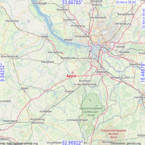
Appel GPS coordinates[2]
53° 23' 26.16" North, 9° 44' 44.34" East
| Map corner | latitude | longitude |
|---|---|---|
| Upper-left | 53.80785°, | 9.04252° |
| Center: | 53.3906°, | 9.74565° |
| Lower-right: | 52.96922°, | 10.44878° |
| Map W x H: | 93.2×93.2 km | = 57.9×57.9mi |
| max Lat: | 55.01917° ⇑15.5% North |
| Appel: | 53.3906° |
| min Lat: | ⇓84.5% South 47.40724° |
| min Long | Appel | max Long |
| 5.92978° | 9.74565° | 14.98853° |
| W 46.4%⇐ | ⇒53.6% E |
Elevation
Elevation of Appel is 30 m = 98 ft, and this is 219.1 m = 719 ft below average elevation for this country.
| Max E: |
1256 m = 4121 ft | 87% |
| Avg. | 249.1 m = 817 ft | |
| Appel | 30 m = 98 ft | |
Min E: |
-5 m = -16 ft | 13% |
See also: Germany elevation on elevation.city.
Geographical zone
Appel is located in North temperate zone (between Tropic of Cancer and the Arctic Circle). Distance of this North polar circle is 1464.7 km =910.1 mi to North.| Distance of | km | miles | from Appel |
|---|---|---|---|
| North Pole | 4070.6 | 2529.4 | to North |
| Arctic Circle | 1464.7 | 910.1 | to North |
| Tropic Cancer | 3330.6 | 2069.5 | to South |
| Equator | 5936.5 | 3688.8 | to South |


Nearby cities:
15 places around Appel: (largest is in red/bold)
• Apensen
9.8 km =6.1 mi,  299°
299°
• Beckdorf
9 km =5.6 mi,  288°
288°
• Buchholz in der Nordheide
10.8 km =6.7 mi,  131°
131°
• Buxtehude
9.4 km =5.8 mi,  335°
335°
• Dohren
10.5 km =6.5 mi,  196°
196°
• Drestedt
6.7 km =4.2 mi,  173°
173°
• Halvesbostel
10.5 km =6.5 mi,  248°
248°
• Heidenau
9.7 km =6 mi,  212°
212°
• Hollenstedt
3.3 km =2.1 mi,  215°
215°
• Kakenstorf
9.8 km =6.1 mi, 173°
• Moisburg
3.6 km =2.2 mi, 299°
• Neu Wulmstorf
9.2 km =5.7 mi,  23°
23°
• Regesbostel
6.4 km =4 mi,  262°
262°
• Sauensiek
9.7 km =6 mi,  265°
265°
• Wenzendorf
4.9 km =3 mi,  158°
158°
Sources, notices
• [Note1] Compared only with cities in Germany existing in our database
• [Src1] Map data: © OpenStreetMap contributors (CC-BY-SA)
• [Src2] Other city data from geonames.org with taken over terms of usage.
• [Src3] Geographical zone / Annual Mean Temperature by Robert A. Rohde @ Wikipedia
