Hollenstedt geodata
Hollenstedt (Lower Saxony) is a seat of a fourth-order administrative division; located in Germany in Europe/Berlin (GMT+2) time zone. With population of 3,092 people, there are 3922 cities with bigger population in this country. Compared to other cities in Germany, 84.2% of cities are located further ↓South; 54.2% of cities are located further →East and 88.9% of cities have higher elevation than Hollenstedt. Note1


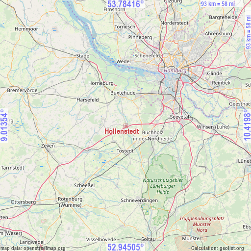
Hollenstedt GPS coordinates[2]
53° 22' 0.012" North, 9° 43' 0.012" East
| Map corner | latitude | longitude |
|---|---|---|
| Upper-left | 53.78416°, | 9.01354° |
| Center: | 53.36667°, | 9.71667° |
| Lower-right: | 52.94505°, | 10.4198° |
| Map W x H: | 93.3×93.3 km | = 58×58mi |
| max Lat: | 55.01917° ⇑15.8% North |
| Hollenstedt: | 53.36667° |
| min Lat: | ⇓84.2% South 47.40724° |
| min Long | Hollenstedt | max Long |
| 5.92978° | 9.71667° | 14.98853° |
| W 45.8%⇐ | ⇒54.2% E |
Elevation
Elevation of Hollenstedt is 24 m = 79 ft, and this is 225.1 m = 739 ft below average elevation for this country.
| Max E: |
1256 m = 4121 ft | 88.9% |
| Avg. | 249.1 m = 817 ft | |
| Hollenstedt | 24 m = 79 ft | |
Min E: |
-5 m = -16 ft | 11.1% |
See also: Germany elevation on elevation.city.
Geographical zone
Hollenstedt is located in North temperate zone (between Tropic of Cancer and the Arctic Circle). Distance of this North polar circle is 1467.4 km =911.8 mi to North.| Distance of | km | miles | from Hollenstedt |
|---|---|---|---|
| North Pole | 4073.2 | 2531 | to North |
| Arctic Circle | 1467.4 | 911.8 | to North |
| Tropic Cancer | 3327.9 | 2067.9 | to South |
| Equator | 5933.8 | 3687.1 | to South |


Nearby cities:
15 places around Hollenstedt: (largest is in red/bold)
• Apensen
9.9 km =6.2 mi,  318°
318°
• Appel
3.3 km =2.1 mi,  35°
35°
• Beckdorf
8.7 km =5.4 mi,  309°
309°
• Buchholz in der Nordheide
11 km =6.8 mi,  114°
114°
• Dohren
7.5 km =4.7 mi,  188°
188°
• Drestedt
4.8 km =3 mi,  146°
146°
• Halvesbostel
7.9 km =4.9 mi,  260°
260°
• Heidenau
6.5 km =4 mi,  210°
210°
• Kakenstorf
7.7 km =4.8 mi,  156°
156°
• Moisburg
4.6 km =2.9 mi,  344°
344°
• Regesbostel
4.8 km =3 mi,  292°
292°
• Sauensiek
8 km =5 mi,  283°
283°
• Tostedt
9.3 km =5.8 mi,  180°
180°
• Wenzendorf
4.2 km =2.6 mi,  117°
117°
• Wistedt
11.3 km =7 mi, 191°
Sources, notices
• [Note1] Compared only with cities in Germany existing in our database
• [Src1] Map data: © OpenStreetMap contributors (CC-BY-SA)
• [Src2] Other city data from geonames.org with taken over terms of usage.
• [Src3] Geographical zone / Annual Mean Temperature by Robert A. Rohde @ Wikipedia
