Moisburg geodata
Moisburg (Lower Saxony) is a seat of a fourth-order administrative division; located in Germany in Europe/Berlin (GMT+2) time zone. With population of 1,802 people, there are 5346 cities with bigger population in this country. Compared to other cities in Germany, 84.6% of cities are located further ↓South; 54.4% of cities are located further →East and 89.7% of cities have higher elevation than Moisburg. Note1


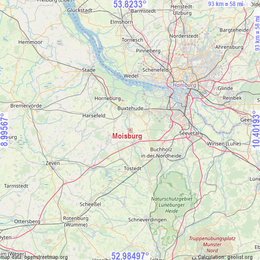
Moisburg GPS coordinates[2]
53° 24' 22.32" North, 9° 41' 55.68" East
| Map corner | latitude | longitude |
|---|---|---|
| Upper-left | 53.8233°, | 8.99567° |
| Center: | 53.4062°, | 9.6988° |
| Lower-right: | 52.98497°, | 10.40193° |
| Map W x H: | 93.2×93.2 km | = 57.9×57.9mi |
| max Lat: | 55.01917° ⇑15.4% North |
| Moisburg: | 53.4062° |
| min Lat: | ⇓84.6% South 47.40724° |
| min Long | Moisburg | max Long |
| 5.92978° | 9.6988° | 14.98853° |
| W 45.6%⇐ | ⇒54.4% E |
Elevation
Elevation of Moisburg is 22 m = 72 ft, and this is 227.1 m = 745 ft below average elevation for this country.
| Max E: |
1256 m = 4121 ft | 89.7% |
| Avg. | 249.1 m = 817 ft | |
| Moisburg | 22 m = 72 ft | |
Min E: |
-5 m = -16 ft | 10.3% |
See also: Germany elevation on elevation.city.
Geographical zone
Moisburg is located in North temperate zone (between Tropic of Cancer and the Arctic Circle). Distance of this North polar circle is 1463 km =909.1 mi to North.| Distance of | km | miles | from Moisburg |
|---|---|---|---|
| North Pole | 4068.8 | 2528.2 | to North |
| Arctic Circle | 1463 | 909.1 | to North |
| Tropic Cancer | 3332.3 | 2070.6 | to South |
| Equator | 5938.2 | 3689.8 | to South |


Nearby cities:
15 places around Moisburg: (largest is in red/bold)
• Apensen
6.2 km =3.9 mi,  298°
298°
• Appel
3.6 km =2.2 mi,  119°
119°
• Beckdorf
5.6 km =3.5 mi,  282°
282°
• Buxtehude
6.8 km =4.2 mi,  353°
353°
• Dohren
11.8 km =7.3 mi,  179°
179°
• Drestedt
9.3 km =5.8 mi,  155°
155°
• Halvesbostel
8.7 km =5.4 mi,  229°
229°
• Heidenau
10.2 km =6.3 mi,  192°
192°
• Hollenstedt
4.6 km =2.9 mi, 164°
• Kakenstorf
12.2 km =7.6 mi, 159°
• Neu Wulmstorf
9.5 km =5.9 mi,  44°
44°
• Nottensdorf
10.8 km =6.7 mi,  322°
322°
• Regesbostel
4.1 km =2.5 mi, 231°
• Sauensiek
7 km =4.3 mi,  248°
248°
• Wenzendorf
8 km =5 mi,  142°
142°
Sources, notices
• [Note1] Compared only with cities in Germany existing in our database
• [Src1] Map data: © OpenStreetMap contributors (CC-BY-SA)
• [Src2] Other city data from geonames.org with taken over terms of usage.
• [Src3] Geographical zone / Annual Mean Temperature by Robert A. Rohde @ Wikipedia
