Anrode geodata
Anrode (Thuringia) is a seat of a fourth-order administrative division; located in Germany in Europe/Berlin (GMT+2) time zone. With population of 3,562 people, there are 3569 cities with bigger population in this country. Compared to other cities in Germany, 62.7% of cities are located further ↓South; 56% of cities are located further ←West and 71.1% of cities have lower elevation than Anrode. Note1


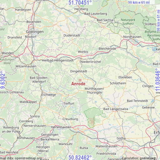
Anrode GPS coordinates[2]
51° 16' 0.012" North, 10° 19' 59.988" East
| Map corner | latitude | longitude |
|---|---|---|
| Upper-left | 51.70451°, | 9.6302° |
| Center: | 51.26667°, | 10.33333° |
| Lower-right: | 50.82462°, | 11.03646° |
| Map W x H: | 97.8×97.8 km | = 60.8×60.8mi |
| max Lat: | 55.01917° ⇑37.3% North |
| Anrode: | 51.26667° |
| min Lat: | ⇓62.7% South 47.40724° |
| min Long | Anrode | max Long |
| 5.92978° | 10.33333° | 14.98853° |
| W 56%⇐ | ⇒44% E |
Elevation
Elevation of Anrode is 367 m = 1204 ft, and this is 117.9 m = 387 ft above average elevation for this country.
| Max E: |
1256 m = 4121 ft | 28.9% |
| Anrode | 367 m 1204 ft | |
| Avg. | 249.1 m = 817 ft | |
Min E: |
-5 m = -16 ft | 71.1% |
See also: Germany elevation on elevation.city.
Geographical zone
Anrode is located in North temperate zone (between Tropic of Cancer and the Arctic Circle). Distance of this North polar circle is 1700.9 km =1056.9 mi to North.| Distance of | km | miles | from Anrode |
|---|---|---|---|
| North Pole | 4306.7 | 2676.1 | to North |
| Arctic Circle | 1700.9 | 1056.9 | to North |
| Tropic Cancer | 3094.4 | 1922.8 | to South |
| Equator | 5700.3 | 3542 | to South |


Nearby cities:
15 places around Anrode: (largest is in red/bold)
• Büttstedt
2 km =1.2 mi,  247°
247°
• Dingelstädt
5.5 km =3.4 mi,  348°
348°
• Effelder
6.7 km =4.2 mi,  243°
243°
• Großbartloff
8.3 km =5.2 mi,  257°
257°
• Helmsdorf
3.9 km =2.4 mi,  17°
17°
• Heuthen
10.6 km =6.6 mi,  313°
313°
• Kallmerode
9.6 km =6 mi, 345°
• Katharinenberg
10.7 km =6.6 mi,  208°
208°
• Kefferhausen
6.6 km =4.1 mi,  327°
327°
• Kleinbartloff
9.9 km =6.2 mi, 20°
• Kreuzebra
10.9 km =6.8 mi, 327°
• Küllstedt
3.8 km =2.4 mi,  285°
285°
• Mühlhausen
10.5 km =6.5 mi,  127°
127°
• Silberhausen
4.9 km =3 mi,  5°
5°
• Wachstedt
6.9 km =4.3 mi,  302°
302°
Sources, notices
• [Note1] Compared only with cities in Germany existing in our database
• [Src1] Map data: © OpenStreetMap contributors (CC-BY-SA)
• [Src2] Other city data from geonames.org with taken over terms of usage.
• [Src3] Geographical zone / Annual Mean Temperature by Robert A. Rohde @ Wikipedia
