Küllstedt geodata
Küllstedt (Thuringia) is a seat of a fourth-order administrative division; located in Germany in Europe/Berlin (GMT+2) time zone. With population of 1,578 people, there are 5726 cities with bigger population in this country. Compared to other cities in Germany, 62.9% of cities are located further ↓South; 54.9% of cities are located further ←West and 81.3% of cities have lower elevation than Küllstedt. Note1


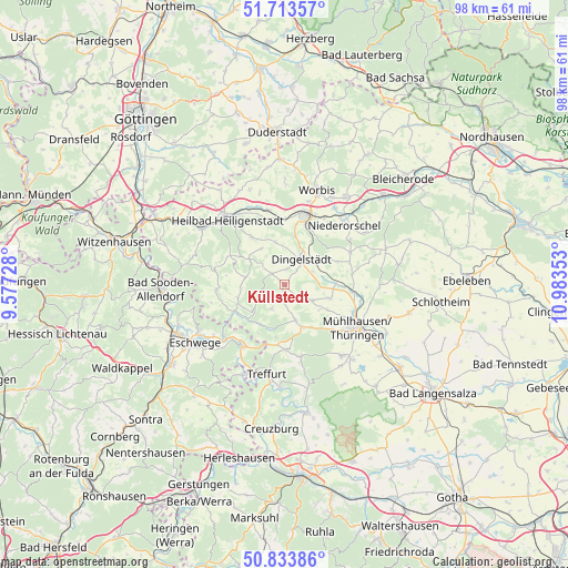
Küllstedt GPS coordinates[2]
51° 16' 32.952" North, 10° 16' 49.44" East
| Map corner | latitude | longitude |
|---|---|---|
| Upper-left | 51.71357°, | 9.57728° |
| Center: | 51.27582°, | 10.2804° |
| Lower-right: | 50.83386°, | 10.98353° |
| Map W x H: | 97.8×97.8 km | = 60.8×60.8mi |
| max Lat: | 55.01917° ⇑37.1% North |
| Küllstedt: | 51.27582° |
| min Lat: | ⇓62.9% South 47.40724° |
| min Long | Küllstedt | max Long |
| 5.92978° | 10.2804° | 14.98853° |
| W 54.9%⇐ | ⇒45.1% E |
Elevation
Elevation of Küllstedt is 442 m = 1450 ft, and this is 192.9 m = 633 ft above average elevation for this country.
| Max E: |
1256 m = 4121 ft | 18.7% |
| Küllstedt | 442 m 1450 ft | |
| Avg. | 249.1 m = 817 ft | |
Min E: |
-5 m = -16 ft | 81.3% |
See also: Germany elevation on elevation.city.
Geographical zone
Küllstedt is located in North temperate zone (between Tropic of Cancer and the Arctic Circle). Distance of this North polar circle is 1699.8 km =1056.2 mi to North.| Distance of | km | miles | from Küllstedt |
|---|---|---|---|
| North Pole | 4305.7 | 2675.4 | to North |
| Arctic Circle | 1699.8 | 1056.2 | to North |
| Tropic Cancer | 3095.4 | 1923.4 | to South |
| Equator | 5701.3 | 3542.6 | to South |


Nearby cities:
15 places around Küllstedt: (largest is in red/bold)
• Anrode
3.8 km =2.4 mi,  105°
105°
• Büttstedt
2.5 km =1.6 mi,  134°
134°
• Dingelstädt
5.1 km =3.2 mi,  30°
30°
• Effelder
4.6 km =2.9 mi,  209°
209°
• Ershausen
8.5 km =5.3 mi,  255°
255°
• Geisleden
10 km =6.2 mi,  325°
325°
• Geismar
9.4 km =5.8 mi,  238°
238°
• Großbartloff
5.3 km =3.3 mi, 237°
• Helmsdorf
5.5 km =3.4 mi,  60°
60°
• Heuthen
7.4 km =4.6 mi, 327°
• Kallmerode
8.4 km =5.2 mi,  9°
9°
• Kefferhausen
4.5 km =2.8 mi,  2°
2°
• Kreuzebra
8.5 km =5.3 mi,  345°
345°
• Silberhausen
5.7 km =3.5 mi,  46°
46°
• Wachstedt
3.4 km =2.1 mi,  321°
321°
Sources, notices
• [Note1] Compared only with cities in Germany existing in our database
• [Src1] Map data: © OpenStreetMap contributors (CC-BY-SA)
• [Src2] Other city data from geonames.org with taken over terms of usage.
• [Src3] Geographical zone / Annual Mean Temperature by Robert A. Rohde @ Wikipedia
